Enable Location

We need your location to show you interesting places around you

Discover nearby places

Find interesting locations and hidden gems around you

Precise directions

Get accurate directions and distances to places

Your location is never shared with other users. It's only used when you tap the location button.

Wawatam Lighthouse

Log in to your account

Start exploring — it's free

Trusted by 62,783 travelers worldwide

Continue with Google
Continue with Apple
or

We will send you a code to connect

By continuing, you accept our Terms and Conditions and our Privacy Policy

Check your inbox

We've sent a pincode in your inbox. Please enter the code below.

Wawatam Lighthouse

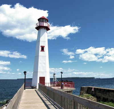
Wawatam Lighthouse, Modern lighthouse in St. Ignace, United States.

Wawatam Lighthouse is a modern structure with a white hexagonal tower and red accents that rises 16 meters above East Moran Bay. Inside, a 250-millimeter Fresnel lens projects its beam across Lake Huron to guide maritime traffic through the Straits of Mackinac.

Originally built in 1998 as a display structure for a Michigan Welcome Center near Monroe, the lighthouse was relocated to St. Ignace in 2004. The structure was reassembled in five sections at its current waterfront location.

The lighthouse takes its name from Chief Wawatam and honors the railroad ferry that once connected the Straits of Mackinac from 1911 until the 1980s. Visitors walking the St. Ignace Boardwalk can reflect on this historical connection as they view the structure.

The lighthouse sits at the end of the St. Ignace Boardwalk and is easily accessible to visitors exploring this waterfront path. Its beam extends across the water to help both boats and, during winter months, snowmobiles traveling on the frozen surface.

The lighthouse has an unexpected backstory as a repurposed structure that was originally designed for a different location. Its disassembly into five sections and transport to the waterfront make it an unusual example of adaptive architecture.

The community of curious travelers

AroundUs brings together thousands of curated places, local tips, and hidden gems, enriched daily by 60,000 contributors worldwide.

Start exploring
Location
Inception
1998
Height
16 m
GPS coordinates
45.86583,-84.71528
Latest update
December 11, 2025 18:08
Around this place
Mackinac Island
United States of America

Mackinac Island

6.6 km
Mackinac Bridge
United States of America

Mackinac Bridge

5.6 km
Grand Hotel
United States of America

Grand Hotel

7.1 km
Fort Mackinac
United States of America

Fort Mackinac

7.8 km
United States of America

Mackinac National Park

7.6 km
Michigan Governor's Summer Residence
United States of America

Michigan Governor's Summer Residence

7.5 km
Castle Rock
United States of America

Castle Rock

5.4 km
Mackinac Bridge Walk
United States of America

Mackinac Bridge Walk

5 km
Skull Cave
United States of America

Skull Cave

7.6 km
Fort Holmes
United States of America

Fort Holmes

7.7 km
Devil's Kitchen
United States of America

Devil's Kitchen

5.9 km
Father Marquette National Memorial
United States of America

Father Marquette National Memorial

1.6 km
Biddle House
United States of America

Biddle House

7.7 km
Straits of Mackinac Shipwreck Preserve
United States of America

Straits of Mackinac Shipwreck Preserve

6.3 km
Straits State Park
United States of America

Straits State Park

1.5 km
Marquette Park
United States of America

Marquette Park

7.8 km
McGulpin House
United States of America

McGulpin House

7.8 km
British Landing
United States of America

British Landing

5.6 km
Robert Stuart House
United States of America

Robert Stuart House

7.7 km
St. Anthony's Rock
United States of America

St. Anthony's Rock

910 m
St. Ignace Mission
United States of America

St. Ignace Mission

1.4 km
Matthew Geary House
United States of America

Matthew Geary House

7.7 km
Mackinac Art Museum
United States of America

Mackinac Art Museum

7.9 km
John Chambers House
United States of America

John Chambers House

643 m
Gros Cap Archaeological District
United States of America

Gros Cap Archaeological District

6.6 km
Marquette Street Archaeological District
United States of America

Marquette Street Archaeological District

1.4 km
Gros Cap and Saint Helena Island Historical Marker
United States of America

Gros Cap and Saint Helena Island Historical Marker

7 km
Market Street Historical Marker
United States of America

Market Street Historical Marker

7.7 km
Show the full map
« Wawatam Lighthouse - Modern lighthouse in St. Ignace, United States » is provided by Around Us (aroundus.com). Images and texts are derived from Wikimedia project under a Creative Commons license. You are allowed to copy, distribute, and modify copies of this page, under the conditions set by the license, as long as this note is clearly visible.

Discover hidden gems everywhere you go!

From secret cafés to breathtaking viewpoints, skip the crowded tourist spots and find places that match your style. Our app makes it easy with voice search, smart filtering, route optimization, and insider tips from travelers worldwide. Download now for the complete mobile experience.

Around Us App Screenshot

A unique approach to discovering new places

Le Figaro

All the places worth exploring

France Info

A tailor-made excursion in just a few clicks

20 Minutes

Around Us
Travel Guide & Maps
Download

Send to your phone

QR Code
1

Open the camera app on your mobile.

2

Point at the QR code with your camera. A notification will appear.

3

Tap the notification to open the link.