Enable Location

We need your location to show you interesting places around you

Discover nearby places

Find interesting locations and hidden gems around you

Precise directions

Get accurate directions and distances to places

Your location is never shared with other users. It's only used when you tap the location button.

Log in to your account

Start exploring — it's free

Trusted by 61,461 travelers worldwide

Continue with Google
Continue with Apple
or

We will send you a code to connect

By continuing, you accept our Terms and Conditions and our Privacy Policy

Check your inbox

We've sent a pincode in your inbox. Please enter the code below.

16th Avenue Bailey Bridge

16th Avenue Bailey Bridge, Military engineering bridge in Markham, Canada

Description

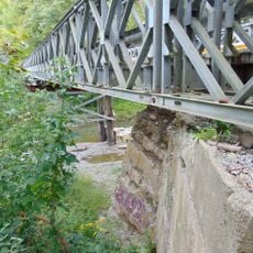
The 16th Avenue Bailey Bridge crosses the Little Rouge Creek with a single traffic lane controlled by signals and measures approximately 21 meters in length. The structure now sits beneath a modern overpass but remains preserved in its original form for future trail use.

History

The Canadian Army built this bridge in 1945 using standardized components designed for quick assembly and deployment. It was constructed to fill infrastructure gaps in the Ontario region during the postwar period.

Culture

A plaque on the structure honors the 2nd Field Engineer Regiment and marks how Canadian military engineers shaped local infrastructure after the war. The inscription connects military capability with community needs in ways visitors can still read today.

Practical

The bridge sits east of Reesor Road within Rouge Park and is accessible on foot, with protective barriers at both ends ensuring safety. Check the park's website for current conditions and any planned work affecting access to the area.

Did you know?

The structure uses Bailey bridge technology, a system of interchangeable steel beams developed during the war that allowed rapid assembly in the field. This building method changed how armies could quickly repair damaged infrastructure and is still used today in disaster zones.

Location
GPS coordinates
43.90240,-79.21420
Latest update
December 14, 2025 11:20

AroundUs brings together thousands of curated places, local tips, and hidden gems, enriched daily by 60,000 contributors worldwide. Discover all places nearby (Ontario).

« 16th Avenue Bailey Bridge - Military engineering bridge in Markham, Canada » is provided by Around Us (aroundus.com). Images and texts are derived from Wikimedia project under a Creative Commons license. You are allowed to copy, distribute, and modify copies of this page, under the conditions set by the license, as long as this note is clearly visible.

Discover hidden gems everywhere you go!

From secret cafés to breathtaking viewpoints, skip the crowded tourist spots and find places that match your style. Our app makes it easy with voice search, smart filtering, route optimization, and insider tips from travelers worldwide. Download now for the complete mobile experience.

Around Us App Screenshot

A unique approach to discovering new places

Le Figaro

All the places worth exploring

France Info

A tailor-made excursion in just a few clicks

20 Minutes

Around Us
Travel Guide & Maps
Download

Send to your phone

QR Code
1

Open the camera app on your mobile.

2

Point at the QR code with your camera. A notification will appear.

3

Tap the notification to open the link.