Piz Aul, Mountain summit in Grisons, Switzerland
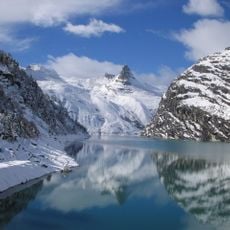
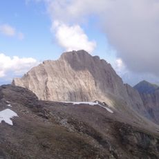
Piz Aul is a 3121 m mountain west of Vals in the Valsertal, Graubünden. Its south side is a continuous wall, while distinct ridges run north and east-northeast. The summit offers a wide panorama due to its geographic dominance.
The peak formed through alpine mountain-building processes millions of years ago, with slate rock composing much of its structure. These geological changes shaped the mountain landscape that exists in the Grisons region today.
The name Piz is Romansh for peak, the language of the Vals valley; the mountain rises west of Vals in the Valsertal. The neighbouring summits carry Romansh names too: the Faltschonhorn (3022 m) to the south and the Piz Serenastga (2874 m) on the north-east ridge. The Leisalp above Vals serves as the base for climbs.
The usual starting point is the Leisalp above Vals. The easiest route, the normal way, climbs the northeast flank from the Sattelilücke saddle at 2763 m. The Breitengrat is rated BG on the SAC hiking scale, equivalent to T6 or at least upper T5. The east face couloir, first climbed in 1909, is rated ZS and its entrance requires UIAA grade IV- climbing.
The easiest route to the summit starts from the Sattelilücke at 2763 m and climbs the northeast flank. The east face couloir, first climbed in 1909, is rated ZS and needs UIAA grade IV- climbing at its entrance. The first winter ascent was made in 1973 by Konrad Berni and Ruedi Vieli.
The community of curious travelers
AroundUs brings together thousands of curated places, local tips, and hidden gems, enriched daily by 94,623 contributors worldwide.