Enable Location

We need your location to show you interesting places around you

Discover nearby places

Find interesting locations and hidden gems around you

Precise directions

Get accurate directions and distances to places

Your location is never shared with other users. It's only used when you tap the location button.

Perlacher Forst

Log in to your account

Start exploring — it's free

Trusted by 61,686 travelers worldwide

Continue with Google
Continue with Apple
or

We will send you a code to connect

By continuing, you accept our Terms and Conditions and our Privacy Policy

Check your inbox

We've sent a pincode in your inbox. Please enter the code below.

Perlacher Forst, Forest and recreation area in southeast Munich, Germany

Description

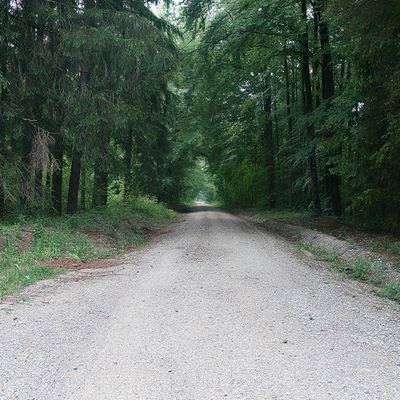
Perlacher Forst is a wooded area in southeast Munich featuring a network of walking paths and cycling routes for visitors to explore on foot or by bicycle. The terrain is mostly covered with trees and offers different trails for various levels of activity.

History

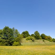
The area was originally developed as a spruce plantation over a century ago and has since become an important recreation area for the city. Hills in the region, particularly the Perlacher Mugl, once served important functions for hunting and observation activities.

Culture

The forest serves as a gathering place where locals spend weekends with family and friends, and beer gardens nestled among the trees are part of the area's social fabric. People come here regularly to meet, eat, and enjoy outdoor time together.

Practical

The forest is accessible from different parts of the city by public transportation, with multiple entry points allowing access from various directions. It remains open year-round and welcomes visitors of all ability levels.

Did you know?

The Perlacher Mugl is a notable hill rising above the surrounding woodland, offering visitors far-reaching views across the landscape from its elevated position. On clear days, this vantage point reveals extensive stretches of the surrounding countryside.

Location
Elevation above the sea
564 m
Part of
Sintura verde de Monaco
GPS coordinates
48.06721,11.57664
Latest update
December 7, 2025 20:20

AroundUs brings together thousands of curated places, local tips, and hidden gems, enriched daily by 60,000 contributors worldwide. Discover all places nearby (Munich).

« Perlacher Forst - Forest and recreation area in southeast Munich, Germany » is provided by Around Us (aroundus.com). Images and texts are derived from Wikimedia project under a Creative Commons license. You are allowed to copy, distribute, and modify copies of this page, under the conditions set by the license, as long as this note is clearly visible.

Discover hidden gems everywhere you go!

From secret cafés to breathtaking viewpoints, skip the crowded tourist spots and find places that match your style. Our app makes it easy with voice search, smart filtering, route optimization, and insider tips from travelers worldwide. Download now for the complete mobile experience.

Around Us App Screenshot

A unique approach to discovering new places

Le Figaro

All the places worth exploring

France Info

A tailor-made excursion in just a few clicks

20 Minutes

Around Us
Travel Guide & Maps
Download

Send to your phone

QR Code
1

Open the camera app on your mobile.

2

Point at the QR code with your camera. A notification will appear.

3

Tap the notification to open the link.