Enable Location

We need your location to show you interesting places around you

Discover nearby places

Find interesting locations and hidden gems around you

Precise directions

Get accurate directions and distances to places

Your location is never shared with other users. It's only used when you tap the location button.

Schwarzer Mann

Log in to your account

Start exploring — it's free

Trusted by 62,840 travelers worldwide

Continue with Google
Continue with Apple
or

We will send you a code to connect

By continuing, you accept our Terms and Conditions and our Privacy Policy

Check your inbox

We've sent a pincode in your inbox. Please enter the code below.

Schwarzer Mann

Schwarzer Mann, Mountain summit in Eifelkreis Bitburg-Prüm, Germany.

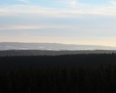
Schwarzer Mann is a mountain summit in the Schnee Eifel region of Rhineland-Palatinate, reaching approximately 698 meters and standing as the highest peak in its range. The massif features extensive quartzite formations that define the landscape's geological character.

The French geographer Jean Joseph Tranchot surveyed the mountain during the Napoleonic period and left a boundary stone called Tranchotstein. This marker recorded the region's political boundaries at that time.

The name came from lead ore miners in Bleialf who returned from underground work with blackened faces. This characteristic shaped how locals understood and named their landscape over time.

The area offers hiking trails with various difficulty levels and is accessible from several nearby towns such as Schlausenbach and Buchelt. In winter, the region transforms into a winter sports destination with skiing facilities and related infrastructure.

The spruce forests on the peak harbor a population of rare European wildcats that few visitors ever spot. This hidden wildlife reveals the mountain's ecological importance beyond its recreational appeal.

The community of curious travelers

AroundUs brings together thousands of curated places, local tips, and hidden gems, enriched daily by 60,000 contributors worldwide.

Start exploring
Elevation above the sea
697.8 m
GPS coordinates
50.25577,6.35995
Latest update
December 10, 2025 15:59
« Schwarzer Mann - Mountain summit in Eifelkreis Bitburg-Prüm, Germany » is provided by Around Us (aroundus.com). Images and texts are derived from Wikimedia project under a Creative Commons license. You are allowed to copy, distribute, and modify copies of this page, under the conditions set by the license, as long as this note is clearly visible.

Discover hidden gems everywhere you go!

From secret cafés to breathtaking viewpoints, skip the crowded tourist spots and find places that match your style. Our app makes it easy with voice search, smart filtering, route optimization, and insider tips from travelers worldwide. Download now for the complete mobile experience.

Around Us App Screenshot

A unique approach to discovering new places

Le Figaro

All the places worth exploring

France Info

A tailor-made excursion in just a few clicks

20 Minutes

Around Us
Travel Guide & Maps
Download

Send to your phone

QR Code
1

Open the camera app on your mobile.

2

Point at the QR code with your camera. A notification will appear.

3

Tap the notification to open the link.