Hermannsdenkmal, Germanic monument in Teutoburg Forest, Germany
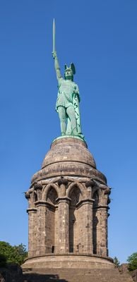
The Hermannsdenkmal is an iron monument in the Teutoburg Forest near Detmold, Germany, showing a warrior figure holding a sword and shield. The figure stands on a sandstone pedestal with Gothic arches and reaches a total height of around 53 meters (174 feet).
Construction began in 1838 following designs by architect Ernst von Bandel and was only completed in 1875 after German unification in 1871 released new funding. The monument commemorates the victory of Cherusci leader Arminius over Roman legions in 9 AD.
The name Hermann comes from the Latinized form Arminius, who became a folk hero figure from the 16th century onward. Visitors today mainly see the connection between iron craftsmanship and patriotic symbolism that was popular in the 19th century.
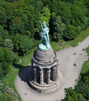
The climb follows a spiral staircase with 75 steps inside the pedestal that leads to an observation platform. The site sits on Grotenburg hill and can be reached on foot through forest paths or by car.
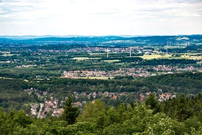
The sword tip points west toward the direction from which the Roman troops approached. On clear days, the observation point offers views of Köterberg, the highest peak in the Weser Uplands.
Location: Detmold
Inception: 1875
Creator: Ernst von Bandel
Official opening: August 16, 1875
Height: 28.62 cm
Accessibility: Wheelchair inaccessible
Made from material: iron
Website: http://hermannsdenkmal.de
GPS coordinates: 51.91165,8.83948
Latest update: December 4, 2025 19:00
Detmold Open-air Museum
2.5 km
Hermannsweg
470 m
Grotenburg
41 m
Vogelpark Heiligenkirchen
1.7 km
Bielstein
1.4 km
Dreiflussstein
2.3 km
Mausoleum Büchenberg
2.3 km
Östlicher Teutoburger Wald
2.2 km
Sanatorium Grotenburg
994 m
Krummes Haus
2.4 km
St. Michael Church
1.5 km
Evangelisch-reformierte Kirche Hiddesen
1.5 km
Kirche Heiligenkirchen
2.2 km
Hohe Warte
2.4 km
St. Stephanus
1.2 km
Kiesgrube Kater
1.7 km
Fire station
1.7 km
Hangstein
2.4 km
Freibad Hiddesen
1.1 km
LSG-Biotopkomplex am Hiddeser Berg
2.3 km
Heidenbach
900 m
Donoperteich-Hiddeser Bent
2.3 km
LSG-Tal westlich Schling
1.4 km
Buchenwald am Südosthang der Grotenburg
636 m
LSG-Scherenbruch
1.9 km
LSG-Hahnberg
2.4 km
LSG-Biotopkomplex am Viethberg
2.5 km
Donoperteich-Hiddeser Bent
2.2 kmReviews
Visited this place? Tap the stars to rate it and share your experience / photos with the community! Try now! You can cancel it anytime.
Discover hidden gems everywhere you go!
From secret cafés to breathtaking viewpoints, skip the crowded tourist spots and find places that match your style. Our app makes it easy with voice search, smart filtering, route optimization, and insider tips from travelers worldwide. Download now for the complete mobile experience.
A unique approach to discovering new places❞
— Le Figaro
All the places worth exploring❞
— France Info
A tailor-made excursion in just a few clicks❞
— 20 Minutes