Autobahnbrücke Siebenlehn
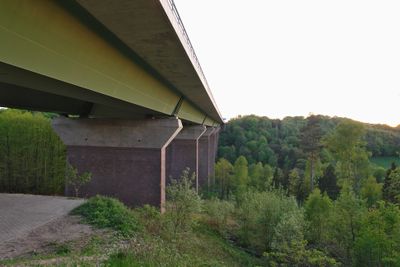
Autobahnbrücke Siebenlehn, Girder bridge in Nossen, Germany
The Autobahnbrücke Siebenlehn is a girder-type structure spanning the Freiberger Mulde valley with a reach of about 413 meters. The framework reaches a height of about 70 meters and carries eight lanes of traffic across the A4 motorway.
Construction began in September 1935 and was completed by November 1936, using red Meissen granite as structural elements. It was built as part of the motorway expansion connecting Dresden to Chemnitz.
The bridge represents a notable engineering achievement of the 20th century, displaying red Meissen granite pillars that cross the valley. Visitors can observe the craftsmanship of regional materials in its support structures.
The bridge is directly accessible from the A4 motorway and offers views of the valley below. It is best seen from nearby rest areas along the route.
At the end of World War II, the bridge was nearly destroyed by planned demolition, but a local innkeeper prevented the detonation. This act saved the structure from being lost.
Location: Nossen
Inception: 1935
Address: Nossen
GPS coordinates: 51.03720,13.31670
Latest update: December 9, 2025 12:20
Schloss Nossen
2.6 km
Rodigtturm
2.2 km
Memorial stone for the naturalist Amalie Dietrich Otto-Altenkirch-Straße 31 (before)
781 m
Dorfkirche Hirschfeld
2.4 km
Schulgebäude (zwei Häuser, durch Laufgang miteinander verbunden) Seminarweg 4
2.4 km
Schmalspurbahnbrücke Freital-Potschappel–Wilsdruff–Nossen
2.4 km
Wasserturm Siebenlehn
1.1 km
Pöppelmannbrücke Nossen
2.5 km
Kirche Siebenlehn
940 m
Schloss Nossen
2.5 km
Wohnhaus in geschlossener Bebauung (mit Ladenausstattung) sowie Hinterhaus Markt 11
2.6 km
Mietshaus in geschlossener Bebauung und Hinterhaus Freiberger Straße 14
2.6 km
Monument to the naturalist Amalie Dietrich outside Wasserturmstraße 27
1.3 km
Dorfkirche Obergruna
2.5 km
Schusterbrunnen
1 km
Wohnhaus in geschlossener Bebauung Markt 21
2.5 km
Wohnhaus in geschlossener Bebauung Freiberger Straße 8
2.6 km
Rathaus Nossen
2.5 km
Wohnhaus in geschlossener Bebauung und Hinterhaus Freiberger Straße 18
2.6 km
Wohnhaus in geschlossener Bebauung Markt 19
2.5 km
Augustusberg Manor
2.1 km
Memorial stone for the naturalist Amalie Dietrich with surrounding open space Amalie-Dietrich-Höhe
704 m
Denkmal für die Gefallenen des Ersten Weltkrieges Dorfstraße 52 (neben)
2.5 km
Wohnhaus und Gedenkplatte (Wandrelief) des Landschaftsmalers Otto Altenkirch Otto-Altenkirch-Straße 26
598 m
Pfarrhaus mit westlichem Torbogen und östlicher Stützmauer mit Einfriedung sowie rückwärtiger Stützmauer an der Otto-Altenkirch-Straße Kirchgasse 3
930 m
Wohnhaus in Ecklage, mit Seitenflügel zum Hof Freiberger Straße 20
2.6 km
Rathaus in halboffener Bebauung Markt 29
1.1 km
Siebenlehner covered bridge
123 mVisited this place? Tap the stars to rate it and share your experience / photos with the community! Try now! You can cancel it anytime.
Discover hidden gems everywhere you go!
From secret cafés to breathtaking viewpoints, skip the crowded tourist spots and find places that match your style. Our app makes it easy with voice search, smart filtering, route optimization, and insider tips from travelers worldwide. Download now for the complete mobile experience.
A unique approach to discovering new places❞
— Le Figaro
All the places worth exploring❞
— France Info
A tailor-made excursion in just a few clicks❞
— 20 Minutes