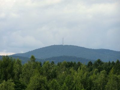
Brotjacklriegel, Mountain summit in Bavarian Forest, Germany
Brotjacklriegel is a mountain in the Bavarian Forest reaching 1011 meters elevation and features a 27-meter wooden observation tower with 127 steps to its viewing platform. The tower offers expansive views across the forested landscape and surrounding valleys from its top.
The first observation tower was built in 1839 by a parish priest and two local innkeepers from the village of Langfurth who sought to make the summit accessible to visitors. This early initiative established the mountain as an important destination in the region.
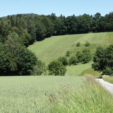
The summit serves as a focal point for the Sonnenwald region and draws visitors who value outdoor activity and connection to nature. Local communities have maintained a relationship with this location for centuries, making it part of their landscape identity.
A two-kilometer trail winds from the Jackl parking area to the summit and includes ten educational stations describing the local forest and wildlife. The path is well-marked, the ascent takes roughly an hour, and the stations provide convenient stopping points along the way.
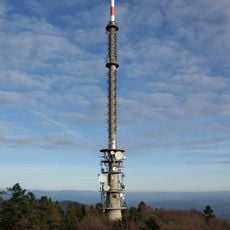
The summit houses both a television and radio transmitter operated by Bavarian Radio and a separate observation tower managed by the Bavarian Forest Club. This dual purpose shows how the mountain serves multiple functions beyond tourism.
Location: Bavaria
Elevation above the sea: 1,011 m
GPS coordinates: 48.81702,13.21673
Latest update: December 10, 2025 16:20
Brotjacklriegel transmitter
63 m
Büchelstein
3.2 km
Wackelstein von Loh
7.7 km
Burg Scharten
6 km
Mitternacher Ohe
7.2 km
St. Johannes und St. Paulus
6.1 km
Wallfahrtskapelle Rastbuche in Grattersdorf
3.4 km
Katholische Pfarrkirche St. Stephan
6.7 km
Katholische Pfarrkirche Mariä Himmelfahrt
1.4 km
Katholische Pfarrkirche St. Josef
3.4 km
Katholische Pfarrkirche St. Pankraz
6.9 km
St. Ägidius
4.9 km
Katholische Pfarrkirche St. Jakobus
4.2 km
Mariä Heimsuchung
6.6 km
Kapelle mit Kirchturm der katholischen Pfarrkirche St. Johannes Baptist
7.4 km
Katholische Pfarrkirche Sieben Schmerzen
2.6 km
Kapelle
7.2 km
Kapelle
5.2 km
Schutz von Landschaftsteilen in den Gemeinden Saldenburg und Thurmannsbang (LSG Lohberg)
7.7 km
Schutz von Landschaftsteilen im Gebiet der Mitternacher Ohe von Gmünd bis Eberhardsreuth, Landkreis Grafenau
7.5 km
Grattersdorf Falkenacker 3
4.6 km
St. Nikolaus
5.8 km
Mitterstallhaus
7.5 km
Kleiner Bildstock
5.8 km
Obere Hengersberger Ohe mit Hangwiesen
7.6 km
Schloss Ranfels
6.9 km
Kurpark
6.2 km
Ehemaliges Austragshaus
4.6 kmVisited this place? Tap the stars to rate it and share your experience / photos with the community! Try now! You can cancel it anytime.
Discover hidden gems everywhere you go!
From secret cafés to breathtaking viewpoints, skip the crowded tourist spots and find places that match your style. Our app makes it easy with voice search, smart filtering, route optimization, and insider tips from travelers worldwide. Download now for the complete mobile experience.
A unique approach to discovering new places❞
— Le Figaro
All the places worth exploring❞
— France Info
A tailor-made excursion in just a few clicks❞
— 20 Minutes