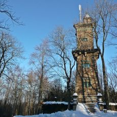
Cottaer Spitzberg, Basalt summit in Sächsische Schweiz-Osterzgebirge, Germany.
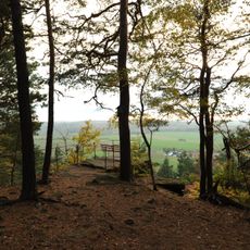
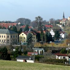
Cottaer Spitzberg is a basalt cone in Sächsische Schweiz rising to approximately 391 meters with striking columnar formations of trachyte basalt. The northern slopes are covered with diverse woodland of oak and hornbeam trees.
During the 19th century, the summit underwent intensive quarrying for basalt extraction, significantly changing the natural landscape. These mining activities removed valuable geological resources from the mountain's structure.
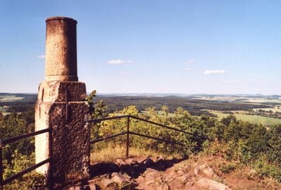
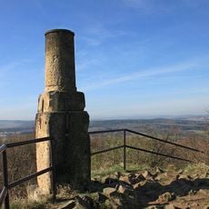
The summit functions as a vital reference point in German land surveying, incorporating a triangulation pillar that connects to other peaks in the measurement network.
Exploration of the summit starts from the designated parking area and follows marked hiking trails to reach the peak. The well-marked paths make navigation straightforward, even during periods of limited visibility.
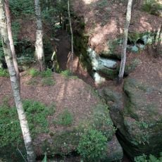
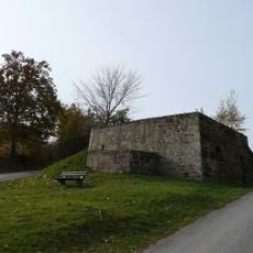
The summit contains a small bunker system built in the early 1960s that served as an emergency command post for the Pirna district. This hidden military facility is a rare Cold War-era remnant in the region.
Location: Sächsische Schweiz-Osterzgebirge
Elevation above the sea: 390.8 m
GPS coordinates: 50.89865,13.96804
Latest update: December 13, 2025 17:02
Labyrinth
4.7 km
Napoleonstein
3.7 km
Schloss Cotta
688 m
Bismarckturm
4 km
Prinzessinsäule Berggießhübel
2.9 km
Langenhennersdorfer Wasserfall
1.8 km
Dorfkirche Friedrichswalde (Bahretal)
4.3 km
Cotta B 3 Dohma
621 m
Eisenbahnstrecke Pirna -Großcotta Dohma
3.6 km
Schloss Ottendorf
3.4 km
Kirche Cotta
693 m
St. Antonius
2.8 km
Protestant Church
3.3 km
Bismarck Tower (Berggießhübel)
4 km
Pappenfabrik Zacharias Ostushenrichwerke
1.7 km
Langenhennersdorf church
3.1 km
Dorfkirche Ottendorf (Bahretal)
3.3 km
Steinkreuz-Gruppe Cotta
795 m
Einzeldenkmale der Sachgesamtheit Rittergut Langenhennersdorf: Herrenhaus über winkligem Grundriss, Wirtschaftsflügel, bestehend aus fünf Gebäuden sowie Toreinfahrt mit zwei Torpfeilern und Gitter (Einzeldenkmal zu ID-Nr. 09304530) Am Sportplatz
3.2 km
Rittergut Langenhennersdorf
3.2 km
Hochwasserdenkmal mit Gedenkstein Sebastian-Kneipp-Straße -
3.3 km
Bahnhof Berggießhübel
2.8 km
Schloss Friedrichsthal
3 km
Station 57 Cottaer Spitzberg
4 m
Gasthaus in Ecklage Friedrichswalde 1
3.8 km
Kalkofen Bad Gottleuba, Kurort
4.5 km
Rittergut Rottwerndorf
2.7 km
Einzeldenkmale der Sachgesamtheit Rittergut Giesenstein: Herrenhaus, zwei Wirtschaftsgebäude, zwei Scheunen, Bergkeller und Einfriedung (Einzeldenkmal zu ID-Nr. 09303855) Giesenstein 1; 1b; 2; 3; 4; 5
4.3 kmVisited this place? Tap the stars to rate it and share your experience / photos with the community! Try now! You can cancel it anytime.
Discover hidden gems everywhere you go!
From secret cafés to breathtaking viewpoints, skip the crowded tourist spots and find places that match your style. Our app makes it easy with voice search, smart filtering, route optimization, and insider tips from travelers worldwide. Download now for the complete mobile experience.
A unique approach to discovering new places❞
— Le Figaro
All the places worth exploring❞
— France Info
A tailor-made excursion in just a few clicks❞
— 20 Minutes