Eringaburg, Iron Age hillfort near Delligsen, Germany
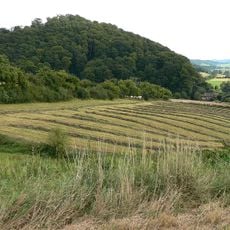
Eringaburg is an Iron Age hillfort on an east-facing spur of the Hils near Ammensen, south of Delligsen. Its plateau is protected by steep slopes to the south and east and by a roughly 300-metre-long curved rampart-and-ditch system to the west and northwest. In the beech forest, the ditch, up to 2 metres deep, is the most visible feature; the rampart was originally 2.5 metres high but has been altered in modern times.
The site dates to the late Iron Age, with the name Eringaburg first recorded in a church document from 1007. Archaeological excavations in 2003 revealed that it was likely used temporarily for defense rather than as a permanent settlement.
The name Eringaburg first appears in a 1007 border description of the Diocese of Hildesheim commissioned by Bishop Bernward, recorded as 'Eringabrug'. In the late 16th century, the Greene estate register mentions 'die ammenser Burg' and 'die ammenser Burgk'. Locals also call the site Hünenburg bei Ammensen.
The site lies in dense beech forest on a spur of the Hils above Ammensen, south of Delligsen. The up-to-2 m deep trench and the curved rampart are best traced in the woods; the steep southern and eastern slopes need care. No masonry or interior structures survive, so the earthworks themselves are what you follow.
The 2003 excavation cut four sections through the ditch and found no stone or timber elements; the wall, originally 2.5 m high, and its ditch were reworked in modern times. No traces of internal divisions were found across the 4.1 ha enclosed area, and prehistoric find layers are entirely absent.
The community of curious travelers
AroundUs brings together thousands of curated places, local tips, and hidden gems, enriched daily by 94,553 contributors worldwide.