Finckenfang

Log in to your account

AroundUs is a community-driven map of interesting places, built by curious explorers like you. It grows with every review, story, and photo you share.
Connect to save your favorite spots, contribute locations, and create personalized routes.
By continuing, you accept our Terms and Conditions and our Privacy Policy

Finckenfang

Add to collection
Map
Suggest a change
Share

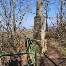
Finckenfang, Mountain peak in Müglitztal, Germany
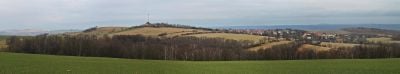
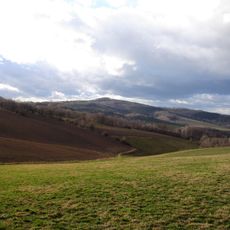
Rising to 394 meters, Finckenfang stands as a northern gateway to the Ore Mountains, offering views across the Lausitzer Bergland and Elbsandsteingebirge regions.

The mountain received its name following the Battle of Maxen in 1759, referencing Prussian General von Finck who surrendered to Austrian forces in nearby Ploschwitz.

Local hiking routes connect Finckenfang to neighboring landmarks, including Wilisch peak and the historic Maxen district, forming a network of regional walking paths.

Several marked trails lead to the summit from Mühlbach, with the primary hiking season extending from May through September when weather conditions remain favorable.

The mountain marks a geological transition point between different formations, representing the northernmost boundary of the Ore Mountain range in Saxony.

Location: Müglitztal

Elevation above the sea: 394 m

GPS coordinates: 50.92226,13.79430

Latest update: March 17, 2025 19:55

Around this place
Show the full map
Wilisch
Germany

Wilisch

3.1 km
Schmorsdorfer Linde
Germany

Schmorsdorfer Linde

2.1 km
Burg Grimmstein
Germany

Burg Grimmstein

3.1 km
Kirche Kreischa
Germany

Kirche Kreischa

3.3 km
Lindenmuseum Clara Schumann
Germany

Lindenmuseum Clara Schumann

2.1 km
Rittergut Kreischa (Rathaus)
Germany

Rittergut Kreischa (Rathaus)

3.4 km
Dorfkirche Maxen Maxener Straße 3
Germany

Dorfkirche Maxen Maxener Straße 3

625 m
Station 61 Wilisch
Germany

Station 61 Wilisch

3.1 km
Friedhof Kreischa (Gartendenkmal), mit Einfriedungsmauer, Baumreihe und Friedhofstor Hermsdorfer Straße -
Germany

Friedhof Kreischa (Gartendenkmal), mit Einfriedungsmauer, Baumreihe und Friedhofstor Hermsdorfer Straße -

3.3 km
Ehem. Maxener Schule, heute Wohnhaus Maxener Straße 6d
Germany

Ehem. Maxener Schule, heute Wohnhaus Maxener Straße 6d

740 m
Wohnhaus Dippoldiswalder Straße 118
Germany

Wohnhaus Dippoldiswalder Straße 118

1.7 km
Kalkofen
Germany

Kalkofen

900 m
Schloss und Stiftsgut Lungkwitz
Germany

Schloss und Stiftsgut Lungkwitz

2.6 km
Bergbaumonumente Maxen (Sachgesamtheit) Maxen
Germany

Bergbaumonumente Maxen (Sachgesamtheit) Maxen

1.6 km
Pfarrhaus, Pfarrgarten mit altem Baumbestand Lungkwitzer Straße 8
Germany

Pfarrhaus, Pfarrgarten mit altem Baumbestand Lungkwitzer Straße 8

3.4 km
Ehemaliges Stiftsgebäude (Einzeldenkmal zu ID-Nr. 09278832) Stiftsgut 3
Germany

Ehemaliges Stiftsgebäude (Einzeldenkmal zu ID-Nr. 09278832) Stiftsgut 3

2.6 km
Denkmal für die Gefallenen des Ersten Weltkrieges Tronitz -
Germany

Denkmal für die Gefallenen des Ersten Weltkrieges Tronitz -

2.9 km
Sachgesamtheit '''Rittergut Maxen''' mit zahlreichen Einzeldenkmalen sowie Gutspark mit zwei Alleen (Sachgesamtheitsteile) Maxener Straße 1; 1a; 1b; 1c; 1d; 1e; 1f; 1g; 2; 2a
Germany

Sachgesamtheit '''Rittergut Maxen''' mit zahlreichen Einzeldenkmalen sowie Gutspark mit zwei Alleen (Sachgesamtheitsteile) Maxener Straße 1; 1a; 1b; 1c; 1d; 1e; 1f; 1g; 2; 2a

1.4 km
Muschelhäuschen (Grotte) und sogenanntes Blaues Häusel (Pavillon) (Einzeldenkmale zu ID-Nr. 09223207)
Germany

Muschelhäuschen (Grotte) und sogenanntes Blaues Häusel (Pavillon) (Einzeldenkmale zu ID-Nr. 09223207)

1.4 km
Villa Dr. Pohl Lungkwitzer Straße 15
Germany

Villa Dr. Pohl Lungkwitzer Straße 15

3.2 km
Häuslerhaus Spitzbergstraße 13
Germany

Häuslerhaus Spitzbergstraße 13

1.7 km
Schloss (Einzeldenkmal zu ID-Nr. 09278832) Stiftsgut 1
Germany

Schloss (Einzeldenkmal zu ID-Nr. 09278832) Stiftsgut 1

2.6 km
Wohnhaus mit rückwärtigem Gebäudeflügel Maxener Straße 7
Germany

Wohnhaus mit rückwärtigem Gebäudeflügel Maxener Straße 7

629 m
Schule Lungkwitz und Wittgensdorf Spitzbergstraße 2
Germany

Schule Lungkwitz und Wittgensdorf Spitzbergstraße 2

2 km
Ehemaliges Stallgebäude, heute Wohnhaus (Einzeldenkmal zu ID-Nr. 09278832) Stiftsgut 2
Germany

Ehemaliges Stallgebäude, heute Wohnhaus (Einzeldenkmal zu ID-Nr. 09278832) Stiftsgut 2

2.5 km
Ehem. Armenhaus, heute Wohnhaus Spitzbergstraße 6
Germany

Ehem. Armenhaus, heute Wohnhaus Spitzbergstraße 6

1.9 km
Wohnhaus Spitzbergstraße 9
Germany

Wohnhaus Spitzbergstraße 9

1.9 km
Wohnhaus (Vierflügelbau um einen Innenhof) Lungkwitzer Straße 6
Germany

Wohnhaus (Vierflügelbau um einen Innenhof) Lungkwitzer Straße 6

3.4 km
Show the full map

Reviews

Visited this place? Tap the stars to rate it and share your experience / photos with the community! Try now! You can cancel it anytime.

« Finckenfang - Mountain peak in Müglitztal, Germany » is provided by Around Us (aroundus.com). Images and texts are derived from Wikimedia project under a Creative Commons license. You are allowed to copy, distribute, and modify copies of this page, under the conditions set by the license, as long as this note is clearly visible.

Discover hidden gems everywhere you go!

From secret cafés to breathtaking viewpoints, skip the crowded tourist spots and find places that match your style. Our app makes it easy with voice search, smart filtering, route optimization, and insider tips from travelers worldwide. Download now for the complete mobile experience.

Around Us App Screenshot

A unique approach to discovering new places

Le Figaro

All the places worth exploring

France Info

A tailor-made excursion in just a few clicks

20 Minutes