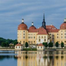
Friedewald, Moritzburger Teichlandschaft und Lößnitz, protected landscape area in Moritzburg, Saxony, Germany
The Friedewald, Moritzburger Teichlandschaft und Lößnitz is a protected landscape area on the western edge of the Lausitz Plateau above the Elbe valley, spanning the municipalities of Moritzburg and Weinböhla and the towns of Coswig and Radeburg. It combines the Friedewald forest with a pond landscape of originally 40 ponds, created around 1500 under Duke Georg the Bearded by damming low-lying depressions. The terrain rises from about 170 metres in the north to about 200 metres in the south, with monzonite bedrock of the Meissen Massif overlaid by cold-age gravel, sand, loess and silt.
The ponds were deliberately created over centuries for fish farming, an activity that sustained the region's economy for a long time. The forests and rolling hills were shaped by glacial processes during ancient ice ages, which left behind the sediment layers and distinctive terrain visible today.
The pond landscape reflects centuries of human use, as the water bodies were created and maintained for fish farming over generations. These water features now define the area's character and show how forestry and fishing shaped the region's identity.
The area is suitable for walking, cycling, and bird watching, with various trails winding through forests and along water bodies. Visitors should be prepared for changing weather conditions and wear appropriate footwear, as the terrain is varied and can be damp in places.
Three officially designated nature reserves within the protected area, Neuteich, Oberer Altenteich, and Frauenteich Moritzburg, serve as wintering grounds and rest stops for rare bird species and migratory birds. These special zones support biodiversity and make the area an important stopover for northern birds traveling between regions.
The community of curious travelers
AroundUs brings together thousands of curated places, local tips, and hidden gems, enriched daily by 95,041 contributors worldwide.