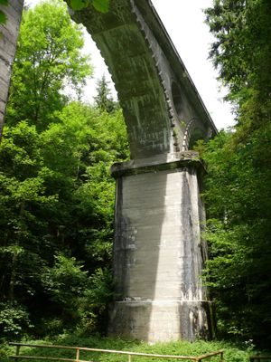
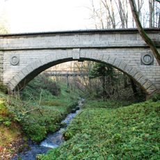
Teufelsgrabenbrücke, Arch bridge and aqueduct in Valley, Germany.
The Teufelsgrabenbrücke is an arch bridge and aqueduct located in Valley near Munich, spanning a considerable distance with four concrete arches and rusticated concrete surfaces. The structure carries water channels along its length, designed to convey water across the valley landscape.
Built in 1890 by engineers Dyckerhoff and Widmann, this structure formed a key component of Munich's water supply system for more than a century. In 1998, a buried conduit replaced its water transport function, marking the end of its original operational purpose.
The bridge features decorative concrete surfaces with arch keystones displaying the Munich coat of arms and the Münchner Kindl symbol. These embellishments shape the structure's appearance and reflect the craftsmanship invested in its design.
The structure is accessible by following valley trails that wind through the landscape and provide good viewing angles from different positions. Year-round access is available, though wet weather can make the surrounding slopes slippery underfoot.
This structure was built from concrete without internal reinforcement and contains no expansion joints or hinges across its entire length. This monolithic construction approach was innovative for the era and showcases early techniques in concrete engineering.
The community of curious travelers
AroundUs brings together thousands of curated places, local tips, and hidden gems, enriched daily by 60,000 contributors worldwide.