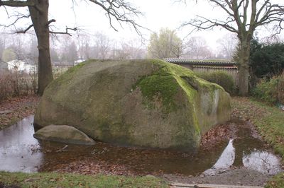
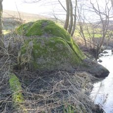
Großer Stein, Glacial erratic in Altentreptow, Germany.
Großer Stein is a granite boulder in Altentreptow with measurements of 8.2 meters long, 6 meters wide, and 5.2 meters tall. Its rough surface texture and substantial size make it a striking feature in the flat surrounding landscape.
The stone traveled about 300 kilometers from the Swedish region of Blekinge during the last glacial period some 25,000 years ago. Ice sheets gradually pushed it southward until it came to rest near Altentreptow.
Local stories speak of two giants who competed in throwing stones at church towers, with this massive boulder landing near a paper mill. The tale connects the rock to the area's identity and shows how people have explained this remarkable stone through folklore.
The stone is easy to reach and can be viewed from all sides, as it was lifted from its partially buried position in 2021. Visitors can examine the complete exterior shape and surface features of the granite formation up close.
The granite composition matches the Swedish Spinkamala type and originated from a mountain formation period roughly 1.4 to 1.5 billion years ago. This age makes the stone far older than many well-known rock formations in Central Europe.
The community of curious travelers
AroundUs brings together thousands of curated places, local tips, and hidden gems, enriched daily by 60,000 contributors worldwide.