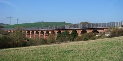
Wommen Viaduct, Arch bridge in Herleshausen, Germany.
The Wommen Viaduct is a stone arch bridge spanning approximately 303 meters across the Nesse Valley while rising about 26 meters high. It consists of multiple connected arches made of red sandstone and carries the roadway of Bundesautobahn 4 over the valley floor.
Construction began in 1938 as part of the Reichsautobahn highway project but was halted by World War 2, leaving the structure incomplete for decades. In the 1990s, after German reunification, the viaduct was fully restored and adapted to meet modern traffic standards.
The structure takes its name from the Wommen stream that flows through the valley below and has become a defining feature of the local landscape. Visitors passing through notice how the massive arches integrate into the surrounding hills and form part of the daily backdrop for the region.
The viaduct is visible from Bundesautobahn 4 and sits in hilly terrain between Herleshausen and the surrounding valleys. Visitors can view the structure from below in the valley or photograph it from nearby local roads.
The bridge displays two distinct parallel structures, with the older section built in the 1940s and the newer section added after 1990, making two different construction styles visible side by side. This arrangement tells the story of a nation rebuilding itself after major upheaval.
The community of curious travelers
AroundUs brings together thousands of curated places, local tips, and hidden gems, enriched daily by 60,000 contributors worldwide.