Enable Location

We need your location to show you interesting places around you

Discover nearby places

Find interesting locations and hidden gems around you

Precise directions

Get accurate directions and distances to places

Your location is never shared with other users. It's only used when you tap the location button.

Talsperre Lichtenberg

Log in to your account

Start exploring — it's free

Trusted by 62,248 travelers worldwide

Continue with Google
Continue with Apple
or

We will send you a code to connect

By continuing, you accept our Terms and Conditions and our Privacy Policy

Check your inbox

We've sent a pincode in your inbox. Please enter the code below.

Talsperre Lichtenberg

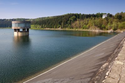
Talsperre Lichtenberg, reservoir in Germany

Talsperre Lichtenberg is a large water storage facility built in the Erzgebirge region to supply the area and prevent flooding. The dam is constructed of stone and stretches 300 meters across the valley, standing about 43 meters above the ground with a bitumen-lined surface to prevent seepage.

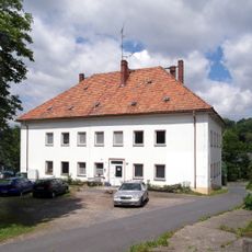
Construction of the reservoir took place from 1966 to 1975, and it became essential for regional water supply and flood control. The project required the relocation of several small communities, reflecting the scale and importance of this infrastructure for the area's development.

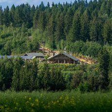
The reservoir is deeply woven into the landscape and frequently visited by locals seeking to enjoy nature and peaceful outdoor time. Hikers, anglers, and people looking for rest shape the atmosphere around the water, making it a place where everyday life touches the natural surroundings.

The dam crest is accessible for walking and offers views of the water and surrounding forests. Parking is available nearby, and the trails around the reservoir are well-maintained and suitable for visitors of all ages.

A distinctive tower on the dam serves for water intake and flood relief, drawing visitor interest with its prominent structure. A small walkway crossing to the tower provides an unusual vantage point over the water surface and often becomes a stopping point for walkers.

The community of curious travelers

AroundUs brings together thousands of curated places, local tips, and hidden gems, enriched daily by 60,000 contributors worldwide.

Start exploring
Location
Elevation above the sea
495 m
GPS coordinates
50.80361,13.46611
Latest update
February 7, 2026 11:40
Around this place
Blockhausen
Germany

Blockhausen

3.2 km
Berlebach
Germany

Berlebach

4.6 km
Burg Lichtenberg
Germany

Burg Lichtenberg

1.1 km
Schule Hauptstraße 30
Germany

Schule Hauptstraße 30

3.1 km
Post-Brücke Mulda/Sa.
Germany

Post-Brücke Mulda/Sa.

3.6 km
Dorfkirche Mulda/Sa.
Germany

Dorfkirche Mulda/Sa.

3.3 km
Wohnhaus Hauptstraße 41
Germany

Wohnhaus Hauptstraße 41

3.3 km
Haltestelle Burkersdorf
Germany

Haltestelle Burkersdorf

2.9 km
Sachgesamtheit Kirche und Kirchhof Mulda mit folgenden Einzeldenkmalen: Kirche, Einfriedungsmauer, sechs Grabmale, zwei Grabanlagen und Nebengebäude (siehe Einzeldenkmalliste - Obj. 09209152, gleiche Anschrift) sowie der Kirchhof als Sachgesamtheits
Germany

Sachgesamtheit Kirche und Kirchhof Mulda mit folgenden Einzeldenkmalen: Kirche, Einfriedungsmauer, sechs Grabmale, zwei Grabanlagen und Nebengebäude (siehe Einzeldenkmalliste - Obj. 09209152, gleiche Anschrift) sowie der Kirchhof als Sachgesamtheits

3.3 km
Brücke über die Freiberger Mulde Oststraße 3
Germany

Brücke über die Freiberger Mulde Oststraße 3

2.8 km
Ehemalige Schule Hauptstraße 35
Germany

Ehemalige Schule Hauptstraße 35

3.2 km
Bauernhaus Hauptstraße 95
Germany

Bauernhaus Hauptstraße 95

4.3 km
Wohnstallhaus Alte Poststraße 1
Germany

Wohnstallhaus Alte Poststraße 1

4.6 km
Häuslerhaus Hauptstraße 74
Germany

Häuslerhaus Hauptstraße 74

3.9 km
Wohnhaus Hauptstraße 2; 3
Germany

Wohnhaus Hauptstraße 2; 3

2.8 km
Pfarrhaus Mittelstraße 1
Germany

Pfarrhaus Mittelstraße 1

3.2 km
Bauernhaus Hauptstraße 1
Germany

Bauernhaus Hauptstraße 1

2.8 km
7 stemmed beech near Frauenstein
Germany

7 stemmed beech near Frauenstein

3.9 km
Eisenhammer Dorfchemnitz
Germany

Eisenhammer Dorfchemnitz

4.3 km
Bahnhof Mulda; Eisenbahnstrecke Mulda-Sayda (Schmalspur); Berthelsdorf-Bienenmühle (ehemals Nossen-Moldau) Mulda/Sa.
Germany

Bahnhof Mulda; Eisenbahnstrecke Mulda-Sayda (Schmalspur); Berthelsdorf-Bienenmühle (ehemals Nossen-Moldau) Mulda/Sa.

3.8 km
Wohnstallhaus Hauptstraße 37
Germany

Wohnstallhaus Hauptstraße 37

3.2 km
Herrenhaus des ehemaligen Rittergutes Am Rittergut 1
Germany

Herrenhaus des ehemaligen Rittergutes Am Rittergut 1

2.6 km
Fischerwassergrenzstein Anton-Günther-Steig
Germany

Fischerwassergrenzstein Anton-Günther-Steig

3.6 km
Kriegerdenkmal für die Gefallenen des Ersten Weltkrieges Anton-Günther-Steig -
Germany

Kriegerdenkmal für die Gefallenen des Ersten Weltkrieges Anton-Günther-Steig -

3.7 km
Brettund Lohmühle Schönlebe; Sägewerk Drechsel ehem. Schönlebe Mulda/Sa.
Germany

Brettund Lohmühle Schönlebe; Sägewerk Drechsel ehem. Schönlebe Mulda/Sa.

4.1 km
Weißer Stein
Germany

Weißer Stein

3.6 km
Seitengebäude eines ehemaligen Erbgerichts Erbgerichtsweg 3
Germany

Seitengebäude eines ehemaligen Erbgerichts Erbgerichtsweg 3

3.4 km
Anton-Günther-Gedenkstein Anton-Günther-Steig -
Germany

Anton-Günther-Gedenkstein Anton-Günther-Steig -

3.8 km
Show the full map
« Talsperre Lichtenberg - reservoir in Germany » is provided by Around Us (aroundus.com). Images and texts are derived from Wikimedia project under a Creative Commons license. You are allowed to copy, distribute, and modify copies of this page, under the conditions set by the license, as long as this note is clearly visible.

Discover hidden gems everywhere you go!

From secret cafés to breathtaking viewpoints, skip the crowded tourist spots and find places that match your style. Our app makes it easy with voice search, smart filtering, route optimization, and insider tips from travelers worldwide. Download now for the complete mobile experience.

Around Us App Screenshot

A unique approach to discovering new places

Le Figaro

All the places worth exploring

France Info

A tailor-made excursion in just a few clicks

20 Minutes

Around Us
Travel Guide & Maps
Download

Send to your phone

QR Code
1

Open the camera app on your mobile.

2

Point at the QR code with your camera. A notification will appear.

3

Tap the notification to open the link.