Rötelstein, Mountain summit in Schlehdorf, Germany.
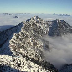
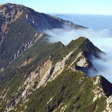
Rötelstein is a 1,394 m high mountain in the Bavarian Prealps east of Ohlstadt, in the Schlehdorf area. It lies 1.1 km from Heimgarten and is climbed as an easy mountain hike from Ohlstadt or from Schlehdorf; both routes call for some surefootedness at the end.
The sources record no documented founding or historical events for the Rötelstein; it appears only as a 1,394 m summit in the Bavarian Prealps east of Ohlstadt. Its two described approaches, from Ohlstadt and from Schlehdorf, are the routes documented for reaching the top, and both require some sure-footedness at the end. The Chinese reference gives an average annual rainfall of 1,715 mm and a distance of 1.1 km to the Heimgarten.
The name Rötelstein refers to the reddish rock of the summit, and the mountain is climbed from two sides: from Ohlstadt and from Schlehdorf. Both routes end with a stretch that requires sure-footedness. The summit stands 1,394 m above sea level in the Bavarian Prealps, 1.1 km from the Heimgarten.
The climb from Schlehdorf follows forest trails marked with yellow signs, making it easy to find your way. The full round trip takes several hours, so starting early and bringing enough water and snacks is important.
The Rötelstein stands 1,394 m above sea level and lies 1.1 km from the Heimgarten, in the Bavarian Prealps east of Ohlstadt. Both approach routes, from Ohlstadt and from Schlehdorf, require some sure-footedness on the final section. Average annual rainfall here is about 1,715 mm.
The community of curious travelers
AroundUs brings together thousands of curated places, local tips, and hidden gems, enriched daily by 93,153 contributors worldwide.