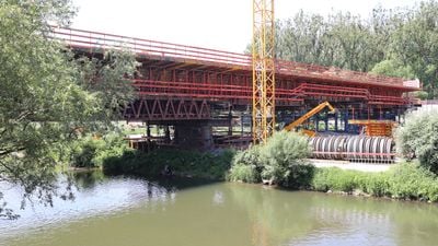
Neckarbrücke Wendlingen, Railway bridge in Wendlingen am Neckar, Germany
The Neckarbrücke Wendlingen is a railway bridge crossing the Neckar River valley to connect trains running between Stuttgart and Ulm. The structure is made of reinforced concrete and rests on substantial pillars anchored deep in the riverbed.
Construction of this bridge started in 2015 following a Europe-wide tender process and was completed in late 2020. It was an important part of a major infrastructure project to improve railway connections in the region.
The bridge represents a major infrastructure development in the Stuttgart-Ulm railway corridor, connecting communities and facilitating regional transportation networks.
The bridge is visible from the Neckar valley and can be viewed from several nearby vantage points. The best views are from the walking paths along the river or from the nearby motorway areas.
During construction, special protective measures were implemented for local animal species and natural habitats to minimize environmental impact. These precautions made the project an example of environmentally responsible bridge construction in Germany.
Location: Wendlingen am Neckar
Inception: December 2020
Part of: Wendlingen–Ulm high-speed railway
GPS coordinates: 48.66629,9.36500
Latest update: December 14, 2025 13:03
Castrum Grinario
1.3 km
Schloss Köngen
2.2 km
Römisches Museum mit Archäologischem Park Köngen
1.3 km
Grienwiesen (Schüle-See)
443 m
Am Rank (Röhmsee)
558 m
Eusebiuskirche
1.9 km
St. Kolumban
657 m
Neckarwasen
2.9 km
Freibad Wendlingen
2.4 km
LSG 'Wendlingen am Neckar' (6 Teilgebiete) vom 25.11.1992
2.2 km
LSG 'Gebiete bei Unterensingen und Zizishausen' (4 Teilgebiete) vom 25.03.1985 geändert am 04.11.1999
2.4 km
Neckarabschnitt
1.7 km
Teich am Tachenhauser Hof
2.2 km
Ulrich Bridge
974 m
Friedenslinde
2 km
Johanneskirche
1.1 km
1 Linde (Silcher-Linde)
1.6 km
1 Linde
1.9 km
1 Linde
1.9 km
1 Linde
1.2 km
2 Linden am Feldhäuschen
1.9 km
3 Eichen (Eichengruppe)
1.8 km
5 Ulmen und 2 Platanen
799 m
1 Eiche
2.3 km
Naturnaher Neckarabschnitt mit Insel (An der Ulrichsbrücke)
680 m
Feldhecke im Gewann Gschraiweg
2.6 km
Ehemaliger Neckaraltarm mit Auenwald
2.9 km
1 Kastanie
1.7 kmVisited this place? Tap the stars to rate it and share your experience / photos with the community! Try now! You can cancel it anytime.
Discover hidden gems everywhere you go!
From secret cafés to breathtaking viewpoints, skip the crowded tourist spots and find places that match your style. Our app makes it easy with voice search, smart filtering, route optimization, and insider tips from travelers worldwide. Download now for the complete mobile experience.
A unique approach to discovering new places❞
— Le Figaro
All the places worth exploring❞
— France Info
A tailor-made excursion in just a few clicks❞
— 20 Minutes