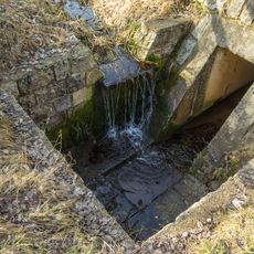
Steinerne Rinne bei Erasbach, Geological formation in Berching, Germany.
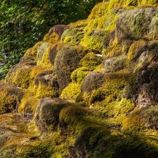
The Steinerne Rinne near Erasbach is a moss-covered limestone tuff channel about 80 metres long and up to 80 centimetres high, with a base up to 85 centimetres and a top edge up to 30 centimetres wide. It runs down the northern slope of the Erasbach hill, becoming lower and narrower before flowing into the Erasbach stream, which empties into the Sulz.
The channel is a very young geological formation, having developed only since the mid-20th century. It grew through lime precipitation, not dissolution: carbon dioxide escapes from the spring water, and algae and mosses cause calcium carbonate to deposit, raising the rim by a few millimetres each year. It is registered as geotope 373R020 by the Bavarian Environment Agency.
The spring at the head of the channel is popularly called Franzosenbrunnen. According to tradition, French soldiers camped near Berching during a drought in the 17th or 18th century and traded water for food. The name's exact origin is not documented.
The formation is best reached from Berching through forest paths near Erasbach. Sturdy footwear is recommended as trail conditions vary depending on the season.
The channel grows upward, not downward: algae on the bed and mosses on the rim precipitate calcium from the spring water, raising the rim a few millimetres each year. The spring, called Franzosenbrunnen, yields about two litres per second, up to nine after rain or snowmelt, at 7.5 to 8.5 °C. Legend links the name to French troops who camped near Berching during a drought in the 17th or 18th century and traded water for food.
The community of curious travelers
AroundUs brings together thousands of curated places, local tips, and hidden gems, enriched daily by 92,632 contributors worldwide.