Käsrinne bei Heidenheim

Log in to your account

AroundUs is a community-driven map of interesting places, built by curious explorers like you. It grows with every review, story, and photo you share.
Connect to save your favorite spots, contribute locations, and create personalized routes.
Continue with Google
Continue with Apple
Continue with X
Continue with Facebook
Continue with email
By continuing, you accept our Terms and Conditions and our Privacy Policy
Create an account

Käsrinne bei Heidenheim

Add to collection
Map
Suggest a change
Share

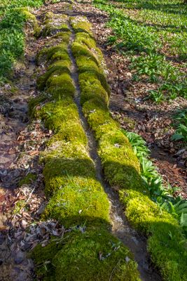
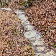
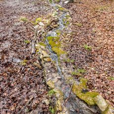
Käsrinne bei Heidenheim, Tuff stream formation in Heidenheim, Germany

Käsrinne is a tuff channel that stretches roughly 150 meters down the western slope of Gelber Berg. Water flows through this natural groove and deposits calcium-rich minerals over time, creating visible basins and terraces along its course.

The channel formed over thousands of years as mineral-rich spring water carved through the slope. Its name comes from the milky appearance that observers noticed in the water long ago.

This geological site stands as the longest stone stream in the Franconian Jura, attracting researchers studying natural limestone formations.

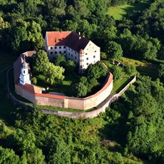
The spring hiking trail from Heidenheim offers the best way to reach this formation. The path goes past Gelber Berg and provides access to the site year-round in various weather conditions.

Two small springs merge above the formation and continuously feed it with mineral-rich water. This steady flow allows the ongoing buildup of the distinctive calcium deposits that make the channel visible.

Location: Heidenheim

Elevation above the sea: 590 m

Length: 150 m

Width: 1 m

Made from material: tuff

Website: http://umweltatlas.bayern.de/mapapps/resources/reports/sb_geotope/generateBericht.pdf?additionallayerfieldvalue=577R018

GPS coordinates: 49.03355,10.73145

Latest update: December 14, 2025 12:26

Photos
Reviews

Visited this place? Tap the stars to rate it and share your experience / photos with the community! Try now! You can cancel it anytime.

« Käsrinne bei Heidenheim - Tuff stream formation in Heidenheim, Germany » is provided by Around Us (aroundus.com). Images and texts are derived from Wikimedia project under a Creative Commons license. You are allowed to copy, distribute, and modify copies of this page, under the conditions set by the license, as long as this note is clearly visible.

Discover hidden gems everywhere you go!

From secret cafés to breathtaking viewpoints, skip the crowded tourist spots and find places that match your style. Our app makes it easy with voice search, smart filtering, route optimization, and insider tips from travelers worldwide. Download now for the complete mobile experience.

Around Us App Screenshot

A unique approach to discovering new places

Le Figaro

All the places worth exploring

France Info

A tailor-made excursion in just a few clicks

20 Minutes