Jünkerath train station, Railway station in Jünkerath, Germany
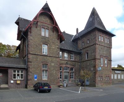
Jünkerath train station is a railway facility in the Eifel region of Rhineland-Palatinate, situated at 429 meters elevation with three platform tracks. The building is constructed in the historicism style and provides connections through the Eifel Railway network.
The station was established in November 1870 by the Rhenish Railway Company as a major transportation point. It played a significant role in military operations during both World Wars in the region.
The station building reflects the architectural style of the late 19th century and preserves the industrial character of German railway infrastructure. It stands as a reminder of how the design of such buildings shaped public spaces during that era.
The station is operated by Deutsche Bahn with regular train services between Cologne and Gerolstein, and digital displays show departure and arrival times. Visitors will find bicycle parking facilities and elevators for easier access throughout the complex.
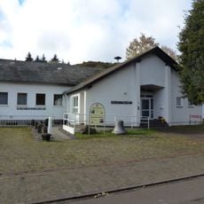
A railway museum stands near the station, displaying regional transport history and historical rail artifacts. The collection reveals how trains shaped the development of the Eifel region over time.
Location: Jünkerath
Official opening: November 1870
Architectural style: historicism
Elevation above the sea: 429 m
Website: http://bahnhof.de/bahnhof-de/Juenkerath
GPS coordinates: 50.34457,6.58077
Latest update: December 9, 2025 12:25
Kalvarienberg
5 km
Heidenköpfe
5.7 km
Saint Joseph Church
3.7 km
Jünkerath Railway Museum
675 m
Protestant Church
430 m
St. Agatha
4.8 km
St. Michael
6.4 km
Ehemalige Steinbrüche am Sönsberg, Lanzenberg und Kaucherbachtal
6 km
St. Antonius
259 m
St. Dionysius
5.2 km
St. Hubertus
2.7 km
Glaadtbachtal mit Nebenbächen
4.2 km
St. Lucia
5.8 km
Kreuzauffindung
1.4 km
Kriegsgräberstätte Blankenheim–Alendorf
5.2 km
St. Medardus
3.1 km
Wiesbaum cemetery chapel
6.5 km
St. Dionysius
3.6 km
In der Wasserdell
4.9 km
St. Paul
1.1 km
Saint Jerome Church (Dahlem, Nordeifel)
5.2 km
Schaafbachtal mit Seitentälern und Stromberg
6.7 km
St. Matthias
6.1 km
St. Hubertus
3.9 km
Kreuz für Johann Oswald Mohr von Wald
6.4 km
Mäuerchenberg, Hierneberg und Pinnert bei Gönnersdorf
2.6 km
Baumberg bei Wiesbaum
4.7 km
Oligsmühle
4.5 kmVisited this place? Tap the stars to rate it and share your experience / photos with the community! Try now! You can cancel it anytime.
Discover hidden gems everywhere you go!
From secret cafés to breathtaking viewpoints, skip the crowded tourist spots and find places that match your style. Our app makes it easy with voice search, smart filtering, route optimization, and insider tips from travelers worldwide. Download now for the complete mobile experience.
A unique approach to discovering new places❞
— Le Figaro
All the places worth exploring❞
— France Info
A tailor-made excursion in just a few clicks❞
— 20 Minutes