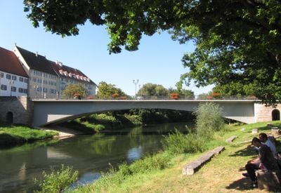
Munderkinger Donaubrücke, Road bridge over Danube River in Munderkingen, Germany
The Munderkinger Donaubrücke crosses the Danube and connects the town center with the northern district and railway station. The current structure includes two traffic lanes and separate pathways on each side for pedestrian use.
The original was built in 1893 as the region's first three-hinged concrete arch bridge and remained in service until its destruction in April 1945. After the war, the bridge was reconstructed in 1948 and has served as a key transport link since then.
The bridge displays a statue of Saint John of Nepomuk, honoring the patron saint of river crossings. Visitors can also see markings on the supports that record past flood levels from different years.
The bridge is freely accessible and provides pedestrians with safe paths to cross from one riverbank to the other. Visitors should note that vehicle traffic uses the bridge during peak hours.
When originally built, this structure was remarkable for its 50-meter concrete arch, as few comparable designs existed worldwide at that time. This technical achievement made it a pioneering example of bridge engineering in its era.
Location: Munderkingen
Inception: 1893
GPS coordinates: 48.23717,9.64366
Latest update: December 9, 2025 18:48
Marchtal Abbey
5.4 km
Schloss Mochental
4.2 km
Kloster Untermarchtal
2.6 km
Klosterkirche Obermarchtal
5.5 km
Blauer Steinbruch
6.8 km
Pfarrkirche St. Dionysius
210 m
Obermarchtal German military cemetery
3.9 km
Pfarrkirche St. Martinus
6.8 km
Burg Reichenstein (Württemberg)
6.8 km
Krippenmuseum Oberstadion
6.7 km
St. Vinzenz
2.7 km
Flusslandschaft Donauwiesen zwischen Zwiefaltendorf und Munderkingen
654 m
Kloster Obermarchtal
5.4 km
Burgrest Emerkingen
3 km
Pfarrkirche St. Sixtus, Reutlingendorf
7 km
Obermarchtal
5.2 km
St. Wolfgang
3 km
Pfannamate-Stoi
5.3 km
Kalkofenmuseum
2.4 km
Grundsheim
6.9 km
Pfarrkirche St. Martinus
6.7 km
Altwuerttemberger Bruennele
6.3 km
Lauterach
6 km
Gasthof zum Ochsen
6.9 km
Keltische Viereckschanze (Obermarchtal)
6.3 km
Schreykapelle
4.2 km
Baumbestand Soldatenfriedhof
3.9 km
Lauterlauf mit Wasserfall und Tuffsteinbruch (30a und b)
6.7 kmVisited this place? Tap the stars to rate it and share your experience / photos with the community! Try now! You can cancel it anytime.
Discover hidden gems everywhere you go!
From secret cafés to breathtaking viewpoints, skip the crowded tourist spots and find places that match your style. Our app makes it easy with voice search, smart filtering, route optimization, and insider tips from travelers worldwide. Download now for the complete mobile experience.
A unique approach to discovering new places❞
— Le Figaro
All the places worth exploring❞
— France Info
A tailor-made excursion in just a few clicks❞
— 20 Minutes