Straßberg, Mountain summit in Zittau, Germany
Straßberg is a mountain summit reaching approximately 538 meters (1,765 feet) within the Zittau range, characterized by densely forested slopes and natural rock outcrops. The terrain offers varied pathways that naturally reveal different perspectives of the surrounding landscape.
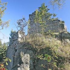
An old Zittau land road, the Gabler Strasse, ran along the western foot of the mountain towards Jablonné v Podještědí. In the 14th century Charles IV had Karlsfried Castle built on a rock spur on the northern slope to protect this route. A ditch of military earthworks crossed by the path to the Fuchskanzel, about 150 m from the forest edge, marks where Napoleon's troops dug in during their 1813 march into Bohemia.
The name Straßberg means "road mountain", after the old Gabler Strasse (Jablonec road) that ran along its western foot toward Jablonné v Podještědí. The viewing rock Fuchskanzel, 200 m northeast of the summit, carries a one-metre sandstone column of the Royal Saxon triangulation, set up in 1864 and now protected; a steel bridge leads onto the rock.
The mountain is reached via established hiking trails starting from Zittau town, with parking available at the mountain's base. Trail conditions vary, and visitors should prepare for typical mountain terrain with elevation changes.
The sandstone pillar on the Fuchskanzel, about one metre tall, was set up in 1864 as "Station 39 Strassberg" of the Royal Saxon triangulation and is now a protected monument. The 10-metre Pilz rock below the Dianawände, popular with climbers for its overhangs, collapsed in February 1994 after prolonged rain.
The community of curious travelers
AroundUs brings together thousands of curated places, local tips, and hidden gems, enriched daily by 92,640 contributors worldwide.