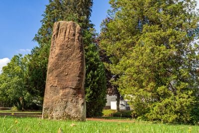
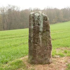
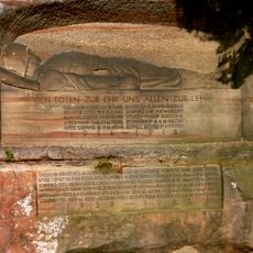
Menhir von Martinshöhe, Prehistoric stone monument in Martinshöhe, Germany.
The Menhir von Martinshöhe is a reddish sandstone block standing about 2.5 meters tall in a small park near the intersection of Am Wasserturm and Zweibrücker streets. The stone's surface displays clear vertical erosion channels that mark its age and long exposure to the elements.
The stone originally stood at twice its current height on Rösberg near Langwieden and was moved multiple times over thousands of years. It reached its present location in Martinshöhe in the 1940s, where it stands beside a war memorial and water tower.
Local residents know this ancient monument by several names including Römerstein, Gollenstein, and 'S Theiße Stään, showing how deeply it is rooted in community memory. These different names reveal how various generations have understood and talked about the stone over time.
The stone stands in an easily accessible park near the marked street intersection and is identified by a war memorial and water tower nearby. Visitors can approach the site at any time to view the monument from different angles and observe the erosion patterns on its surface.
The stone once bore the inscription 'SPQR', the Latin abbreviation for Roman authority, which led to it being mistaken for a Roman marker for centuries. Although these markings have vanished, the legend of the so-called Römerstein endures in local tradition.
The community of curious travelers
AroundUs brings together thousands of curated places, local tips, and hidden gems, enriched daily by 60,000 contributors worldwide.