Mayenne, River system in Pays de la Loire, France
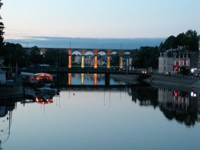
The Mayenne is a river in northwestern France that winds through the Pays de la Loire region, connecting multiple towns. The waterway has moderate width and flows gently through a mix of rural and urban areas.
The river formed an important transport route and industrial hub in the 16th century for the region. Its role as a trade corridor shaped the development of surrounding towns.
The river has been central to local life for centuries, where fishermen and boaters continue to work its waters. Today, visitors can observe these traditions while walking along the banks.
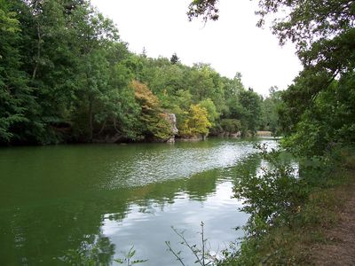
The river offers several access points for boating and water activities, particularly between spring and autumn. The banks are easy to reach and invite walks and exploration of different riverside sections.
The river creates a natural boundary between different geological layers, resulting in noticeably different landscapes on each bank. These geological differences also shape the plant and animal life on either side.
GPS coordinates: 48.45640,-0.13170
Latest update: December 7, 2025 19:30
Mont des Avaloirs
1.1 km
Normandie-Maine Regional Natural Park
7.6 km
Butte Chaumont
8.2 km
Belvédère du mont des Avaloirs
1.1 km
Réserve naturelle régionale Mont des Avaloirs
2.3 km
Église Saint-Julien de Saint-Julien-des-Églantiers
6.5 km
Église Saint-Pierre-et-Saint-Paul de La Roche-Mabile
6.9 km
Pierre au Diable de Saint-Pierre-des-Nids
7.5 km
Église Saint-Pierre de Saint-Pierre-des-Nids
6.8 km
Manoir de Ravigny
5.2 km
Église Saint-Pierre (Pacé)
9.5 km
Église Saint-Julien de Ravigny
5.2 km
Église Sainte-Thérèse de Pré-en-Pail
4.9 km
Église Sainte-Marie de Boulay-les-Ifs
4 km
Église Saint-Martin de Champfrémont
4.3 km
Église Saint-Cyr-et-Sainte-Julitte de Saint-Cyr-en-Pail
8.5 km
Chapelle Sainte-Anne de Champfrémont
3.4 km
Église Saint-Samson de Saint-Samson
5.2 km
Chapelle Notre-Dame-du-Bon-Secours de Saint-Cyr-en-Pail
8.7 km
Chapelle du bourg de Gesvres
9.8 km
Église Notre-Dame de La Ferrière-Bochard
8.8 km
Église de Saint-Denis-sur-Sarthon
6.1 km
Église Notre-Dame de Gandelain
4.1 km
Église Saint-Pierre de Ciral
4.2 km
Église Saint-André de Livaie
9.8 km
Église Saint-Martin de Lalacelle
2.3 km
Église Saint-Pierre de Longuenoë
8.3 km
Église Saint-Ellier de Saint-Ellier-les-Bois
7.5 kmVisited this place? Tap the stars to rate it and share your experience / photos with the community! Try now! You can cancel it anytime.
Discover hidden gems everywhere you go!
From secret cafés to breathtaking viewpoints, skip the crowded tourist spots and find places that match your style. Our app makes it easy with voice search, smart filtering, route optimization, and insider tips from travelers worldwide. Download now for the complete mobile experience.
A unique approach to discovering new places❞
— Le Figaro
All the places worth exploring❞
— France Info
A tailor-made excursion in just a few clicks❞
— 20 Minutes