Montagnette, Mountain range in Bouches-du-Rhône, France.
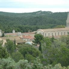
Montagnette is a low limestone ridge between Avignon and Tarascon, in the northwest of Bouches-du-Rhône, bounded by the Rhône and the Durance. It covers about 6,000 hectares, two thirds of them Aleppo pine, and its pale grey rock breaks through the scrub on rounded crests. Its highest point, the Rochers de Raous, reaches 168 m on the Boulbon commune, some 800 m west of the Abbey of Saint-Michel de Frigolet.
On the eastern side, in the commune of Graveson beside the railway line, stands the oppidum of La Roque, a settlement dated to the 6th century BCE. Below this rocky spur, traces of ancient occupation and a long-used cemetery have been found. The massif may have served as a camp for the legions of Caius Marius awaiting the Cimbri and Teutones in 105 BCE; Hannibal's troops with their elephants may also have passed after crossing the Rhone in 218 BCE.
The name Montagnette is a diminutive of the Provençal montanha, and the hill is still called La Montanheta in Occitan. The Roman camp is unproven: the French source mentions 30,000 legionaries of Caius Marius waiting in 105 BCE, the German one 10,000 in 103 BCE. Hannibal's 27 elephants (German source: 300) may have crossed here in 218 BCE.
The massif is classed as a zone rouge because of fire risk, with restrictions on access in summer; the blaze of 14 July 2022 burned 1,600 hectares. The highest point, the Rochers de Raous at 168 m, lies on Boulbon about 800 m west of the Abbey of Saint-Michel de Frigolet. The Oppidum de la Roque sits on the eastern side at Graveson, beside the railway line.
The 14 July 2022 fire burned 1,600 hectares, mostly in Graveson and Barbentane, and over 1,000 firefighters were deployed; the resources committed saved the Abbey of Saint-Michel de Frigolet, about 800 metres east of the 168-metre Rochers de Raous summit.
The community of curious travelers
AroundUs brings together thousands of curated places, local tips, and hidden gems, enriched daily by 93,524 contributors worldwide.