General levelling of France, Spatial reference system in Marseille, France
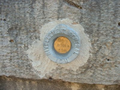
The General Levelling of France is a network of elevation benchmarks distributed across mainland France and Corsica. These reference points are anchored to tide gauge stations in Marseille and Ajaccio, which serve as the zero-level baselines for all height measurements in the country.
The project was launched in the 1800s to establish a single vertical measurement standard for the entire nation. This unified approach to elevation surveying became essential for coordinating construction and infrastructure development across France.
The French General Levelling system reflects the national commitment to scientific precision through its systematic approach to measuring and documenting land elevations.
Engineers and surveyors rely on this network to obtain accurate elevation data for planning and executing construction projects of any scale. The reference points are regularly maintained to ensure all measurements across the country remain consistent and reliable.
The system operates through two distinct networks: NGF-IGN69 anchored to Marseille's tide station for mainland France, and NGF-IGN78 using Ajaccio's measurements for Corsica. This separation reflects the different tidal patterns and geographical conditions of each region.
The community of curious travelers
AroundUs brings together thousands of curated places, local tips, and hidden gems, enriched daily by 60,000 contributors worldwide.