Enable Location

We need your location to show you interesting places around you

Discover nearby places

Find interesting locations and hidden gems around you

Precise directions

Get accurate directions and distances to places

Your location is never shared with other users. It's only used when you tap the location button.

Barrage de Lavalette

Log in to your account

Start exploring — it's free

Trusted by 61,938 travelers worldwide

Continue with Google
Continue with Apple
or

We will send you a code to connect

By continuing, you accept our Terms and Conditions and our Privacy Policy

Check your inbox

We've sent a pincode in your inbox. Please enter the code below.

Barrage de Lavalette

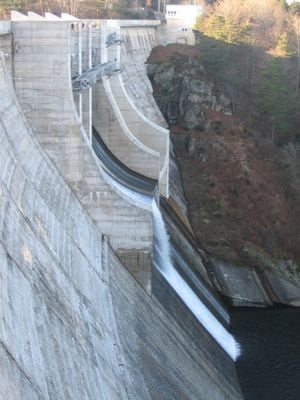
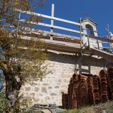
Barrage de Lavalette, Hydraulic dam in Lapte and Saint-Jeures, France.

Lavalette Dam is a concrete structure built across a valley in the Haute-Loire region between the villages of Lapte and Saint-Jeures. The construction holds back a large reservoir that supplies water to surrounding communities and contributes to local electricity production.

The dam was built in 1914, replacing earlier structures that had served the region. After 1949, its storage capacity was significantly enlarged to meet growing demands for water and electricity in the surrounding area.

The dam supplies drinking water to Saint-Étienne through the Chapelette dam and generates electricity at the Versilhac hydroelectric plant.

The best time to visit is during warmer months when access roads are most passable. The site is largely open to view, but stay in designated areas and be cautious if weather conditions change.

In 1974, the structure was inspected using a specialized submarine originally designed for deep-sea exploration. This unusual inspection method allowed detailed examination of the dam without draining the water it held back.

The community of curious travelers

AroundUs brings together thousands of curated places, local tips, and hidden gems, enriched daily by 60,000 contributors worldwide.

Start exploring
Location
Address
9 La Chazotte, 43200 Lapte, France
Opening Hours
Thursday 00:00-00:00
GPS coordinates
45.14995,4.21177
Latest update
December 6, 2025 17:41
Lakes of Auvergne-Rhône-Alpes: volcanic craters, glacier waters, mountain dams

The Auvergne-Rhône-Alpes area has lakes from very different beginnings. Large lakes that formed from glaciers, like Lake Bourget or Lake Annecy, appeared after the glaciers in the Alps melted. They have deep water surrounded by mountains. In the Massif Central, volcanic lakes sit in old craters,...

« Barrage de Lavalette - Hydraulic dam in Lapte and Saint-Jeures, France » is provided by Around Us (aroundus.com). Images and texts are derived from Wikimedia project under a Creative Commons license. You are allowed to copy, distribute, and modify copies of this page, under the conditions set by the license, as long as this note is clearly visible.

Discover hidden gems everywhere you go!

From secret cafés to breathtaking viewpoints, skip the crowded tourist spots and find places that match your style. Our app makes it easy with voice search, smart filtering, route optimization, and insider tips from travelers worldwide. Download now for the complete mobile experience.

Around Us App Screenshot

A unique approach to discovering new places

Le Figaro

All the places worth exploring

France Info

A tailor-made excursion in just a few clicks

20 Minutes

Around Us
Travel Guide & Maps
Download

Send to your phone

QR Code
1

Open the camera app on your mobile.

2

Point at the QR code with your camera. A notification will appear.

3

Tap the notification to open the link.