Enable Location

We need your location to show you interesting places around you

Discover nearby places

Find interesting locations and hidden gems around you

Precise directions

Get accurate directions and distances to places

Your location is never shared with other users. It's only used when you tap the location button.

Pierre Fiche menhir

Log in to your account

Start exploring — it's free

Trusted by 62,004 travelers worldwide

Continue with Google
Continue with Apple
or

We will send you a code to connect

By continuing, you accept our Terms and Conditions and our Privacy Policy

Check your inbox

We've sent a pincode in your inbox. Please enter the code below.

Pierre Fiche menhir

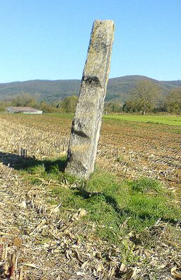
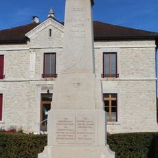
Pierre Fiche menhir, Neolithic menhir in Simandre-sur-Suran, France.

Pierre Fiche is an upright stone block from the Neolithic period, rising approximately 3.8 meters high on private land near the Suran River. The monument spans about 1.3 meters in length and half a meter across at its base.

The stone received protected monument status in 1888, making it the oldest officially classified structure in the Ain department. This recognition reflected authorities' understanding of the archaeological importance of such megalithic structures in the region.

The name translates to "pointed stone" in French. Local stories speak of three fairies who turned spinning wheels into stones, with this menhir and two other now-vanished stones being part of that tale.

The menhir stands on private property but can be viewed from a nearby hiking trail that runs along the Suran River. Visitors should respect the private land and observe from the path.

Research suggests this stone dates from the Middle Neolithic period, roughly between 4200 and 3600 BCE. This timeframe connects it to similar structures discovered in the nearby Burgundy region.

The community of curious travelers

AroundUs brings together thousands of curated places, local tips, and hidden gems, enriched daily by 60,000 contributors worldwide.

Start exploring
Elevation above the sea
308 m
Height
3.8 m
Length
1.3 m
Width
0.5 m
GPS coordinates
46.23257,5.42167
Latest update
December 6, 2025 17:49
Natural and cultural spots in Auvergne-Rhône-Alpes

The Auvergne-Rhône-Alpes region offers a mix of nature and history. Walking paths lead through valleys and past waterfalls, while medieval castles stand on hilltops and ridges. Volcanic peaks rise from the landscape, and caves open into the earth below. You will find the Massif Central, alpine...

« Pierre Fiche menhir - Neolithic menhir in Simandre-sur-Suran, France » is provided by Around Us (aroundus.com). Images and texts are derived from Wikimedia project under a Creative Commons license. You are allowed to copy, distribute, and modify copies of this page, under the conditions set by the license, as long as this note is clearly visible.

Discover hidden gems everywhere you go!

From secret cafés to breathtaking viewpoints, skip the crowded tourist spots and find places that match your style. Our app makes it easy with voice search, smart filtering, route optimization, and insider tips from travelers worldwide. Download now for the complete mobile experience.

Around Us App Screenshot

A unique approach to discovering new places

Le Figaro

All the places worth exploring

France Info

A tailor-made excursion in just a few clicks

20 Minutes

Around Us
Travel Guide & Maps
Download

Send to your phone

QR Code
1

Open the camera app on your mobile.

2

Point at the QR code with your camera. A notification will appear.

3

Tap the notification to open the link.