Plateau de la Danse, Rocky outcrop above the Loire in Saint-Étienne, Loire, France
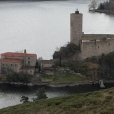
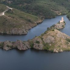
The Plateau de la Danse is a rocky outcrop on the commune of Saint-Étienne, 16 km from the city centre, overlooking the Loire. From this south-north oriented plateau, the view takes in the village of Saint-Victor, the water sports base at its foot and the hamlet of Les Condamines behind. The Grangent dam, 2 km away, is hard to make out because the river's meanders block the horizontal sightline.
The region remained sparsely populated for centuries due to its difficult terrain, though it attracted those seeking natural resources and outdoor pursuits. The construction of the Grangent dam transformed the landscape and created the current reservoir system that shapes the area today.
The plateau takes its name from its flat, stage-like top above the Loire. It lies on the Saint-Étienne commune, 16 km from the town centre, and its south-north orientation frames the village of Saint-Victor, the boating base below and the hamlet of Les Condamines behind. Cyclists, walkers and riders come for the rough relief.
Road access to the plateau is not easy, as with most sites along the Loire gorges. The site lies 16 km from the centre of Saint-Étienne and is reached by paths over a tormented relief; cyclists, walkers and riders use it. Sturdy shoes help on the uneven ground.
The plateau lies 16 km from Saint-Étienne town centre, on a rocky knoll above the Loire. From its south-north orientation you can pick out the village of Saint-Victor, the water-sports base at its foot and the hamlet of Les Condamines behind. The Grangent dam that created the reservoir is 2 km away and hidden by the river's meanders.
The community of curious travelers
AroundUs brings together thousands of curated places, local tips, and hidden gems, enriched daily by 94,634 contributors worldwide.