Enable Location

We need your location to show you interesting places around you

Discover nearby places

Find interesting locations and hidden gems around you

Precise directions

Get accurate directions and distances to places

Your location is never shared with other users. It's only used when you tap the location button.

Pont de Bezons

Log in to your account

Start exploring — it's free

Trusted by 60,664 travelers worldwide

Continue with Google
Continue with Apple
or

We will send you a code to connect

By continuing, you accept our Terms and Conditions and our Privacy Policy

Check your inbox

We've sent a pincode in your inbox. Please enter the code below.

Pont de Bezons

Pont de Bezons, Tram bridge in Nanterre, France

Description

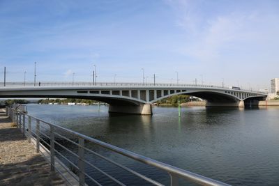
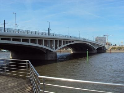
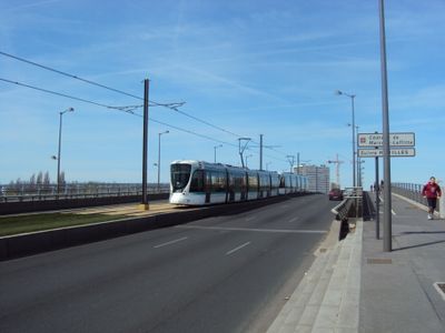
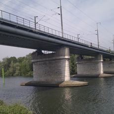
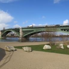
The Pont de Bezons is a bridge across the Seine connecting Nanterre and Colombes on the left bank with Bezons on the right bank. The structure carries both regular vehicle traffic and the T2 tram line, spanning approximately 205 meters over the river's curve.

History

The structure was originally built in wood in 1811 under Napoleon I and had to be reconstructed multiple times after damage from warfare. The reinforced concrete form that exists today emerged from major rebuilding efforts following wartime destruction.

Culture

The bridge takes its name from Bezons, the town on the right bank of the Seine. Today it serves as a daily crossing point for commuters and residents who rely on it to move between communities.

Practical

The bridge is open for pedestrians, cyclists, and vehicle traffic, providing access to the T2 tram which links the area to major transit hubs. Visiting during early morning or late afternoon hours offers less crowding compared to peak commute times.

Did you know?

The bridge became the site of a commemoration ceremony in 2021 honoring historical events from October 17, 1961. This gathering marked a significant moment of remembrance at this crossing point.

Location
Inception
1953
Length
205 m
Part of
street network of Nanterre
Shares border with
boulevard du Havre
GPS coordinates
48.92060,2.22031
Latest update
December 11, 2025 11:03

AroundUs brings together thousands of curated places, local tips, and hidden gems, enriched daily by 60,000 contributors worldwide. Discover all places nearby (Nanterre).

« Pont de Bezons - Tram bridge in Nanterre, France » is provided by Around Us (aroundus.com). Images and texts are derived from Wikimedia project under a Creative Commons license. You are allowed to copy, distribute, and modify copies of this page, under the conditions set by the license, as long as this note is clearly visible.

Discover hidden gems everywhere you go!

From secret cafés to breathtaking viewpoints, skip the crowded tourist spots and find places that match your style. Our app makes it easy with voice search, smart filtering, route optimization, and insider tips from travelers worldwide. Download now for the complete mobile experience.

Around Us App Screenshot

A unique approach to discovering new places

Le Figaro

All the places worth exploring

France Info

A tailor-made excursion in just a few clicks

20 Minutes

Around Us
Travel Guide & Maps
Download

Send to your phone

QR Code
1

Open the camera app on your mobile.

2

Point at the QR code with your camera. A notification will appear.

3

Tap the notification to open the link.