Île-aux-Pies, River island in Bains-sur-Oust, France
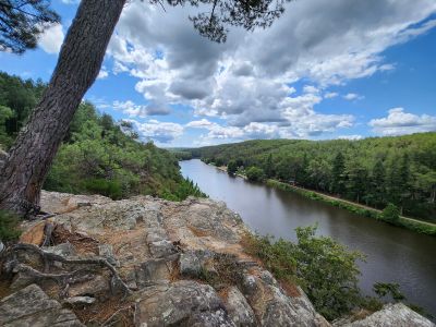
Île-aux-Pies is a river island in Bains-sur-Oust situated where three municipalities meet, featuring rocky cliffs that drop toward the Oust River. The terrain is surrounded by marshland and forest.
The lower Oust valley was classified a Grand Site naturel on 18 May 1981, covering about 25 km across eight communes in Ille-et-Vilaine and Morbihan — the only such site in Brittany away from the coast. On the west bank, the Houssac granite quarry was worked until 1930, when around a hundred workers filled a barge daily by wheelbarrow, shipping stone down the Oust.
The island gives its name to the Grand Site naturel de l'Île-aux-Pies et de la basse vallée de l'Oust, classified on 18 May 1981 along some 25 km of the Oust between Ille-et-Vilaine and Morbihan. Eight communes share the site, which takes in part of the Nantes-Brest canal, locks, a grafted chestnut orchard and old granite, slate and clay quarries. Eleven waymarked footpaths cross the sector, among them the sentier des Mariniers and Le Trésor de l'île aux Pies.
The island is reached only by a single bridge over the Rio de la Borde, on the Bains-sur-Oust side. Eleven waymarked walking trails cross the lower Oust valley, including the Rives du Rio de la Borde and the Parcours de l'écluse. On the Bains-sur-Oust slopes, the cliffs hold more than sixty climbing routes of different levels.
The island lies at the confluence of the Aff and the Oust, and its name refers to magpies (pies). The 25 km of the lower Oust around it was classified a Grand Site naturel on 18 May 1981, the only such site in Brittany away from the coast. The granite quarry of Le Houssac on the west bank employed about a hundred workers until 1930, and a barge was loaded daily by wheelbarrow.
The community of curious travelers
AroundUs brings together thousands of curated places, local tips, and hidden gems, enriched daily by 92,864 contributors worldwide.