Enable Location

We need your location to show you interesting places around you

Discover nearby places

Find interesting locations and hidden gems around you

Precise directions

Get accurate directions and distances to places

Your location is never shared with other users. It's only used when you tap the location button.

Pic de Cabaliros

Log in to your account

Start exploring — it's free

Trusted by 61,907 travelers worldwide

Continue with Google
Continue with Apple
or

We will send you a code to connect

By continuing, you accept our Terms and Conditions and our Privacy Policy

Check your inbox

We've sent a pincode in your inbox. Please enter the code below.

Pic de Cabaliros

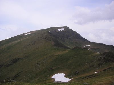
Pic de Cabaliros, Mountain summit in Hautes-Pyrénées, France

Pic de Cabaliros is a 2334-meter summit rising between two major valleys with steep slopes alternating with open meadows. The terrain offers views across to neighboring peaks and forms part of the western Pyrenean range.

The mountain served as a regular destination for herders and mountain dwellers who used the high meadows for their livestock. It gained recognition in the 19th century as an achievable peak among climbers exploring the region.

The name Cabaliros comes from a history of pastoral practices where horses and livestock grazed on these slopes. You can sense this rural heritage by observing the meadows and stone structures that still dot the landscape.

Multiple marked hiking trails start from Pierrefitte-Nestalas and climb through forest sections before opening to alpine meadows. Proper footwear and physical fitness are important because the routes involve steady climbing through varied terrain.

An orientation table installed at the summit in 1993 points out the names and directions of surrounding peaks. This allows visitors to identify and understand hundreds of mountains across the wider Pyrenean massif.

The community of curious travelers

AroundUs brings together thousands of curated places, local tips, and hidden gems, enriched daily by 60,000 contributors worldwide.

Start exploring
Elevation above the sea
2,334 m
GPS coordinates
42.93000,-0.12592
Latest update
December 14, 2025 20:03
« Pic de Cabaliros - Mountain summit in Hautes-Pyrénées, France » is provided by Around Us (aroundus.com). Images and texts are derived from Wikimedia project under a Creative Commons license. You are allowed to copy, distribute, and modify copies of this page, under the conditions set by the license, as long as this note is clearly visible.

Discover hidden gems everywhere you go!

From secret cafés to breathtaking viewpoints, skip the crowded tourist spots and find places that match your style. Our app makes it easy with voice search, smart filtering, route optimization, and insider tips from travelers worldwide. Download now for the complete mobile experience.

Around Us App Screenshot

A unique approach to discovering new places

Le Figaro

All the places worth exploring

France Info

A tailor-made excursion in just a few clicks

20 Minutes

Around Us
Travel Guide & Maps
Download

Send to your phone

QR Code
1

Open the camera app on your mobile.

2

Point at the QR code with your camera. A notification will appear.

3

Tap the notification to open the link.