Dolmen du Coll de la Llosa, Megalithic corridor dolmen in Saint-Michel-de-Llotes, Pyrénées-Orientales, France
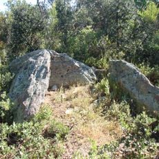
The Dolmen du Coll de la Llosa is a corridor dolmen: a trapezoidal chamber extended by a passage 2.50 m long and about 50 cm wide, built of gneiss and schist blocks taken on site. It crosses a circular tumulus about ten metres in diameter. The schist cover slab, 1.50 m by 2.40 m and 35 cm thick, rests on upright stones, with an entrance facing east.
This megalithic monument originated in the fourth millennium BCE during the Neolithic period. It functioned as a communal burial ground for the earliest inhabitants of the region.
The name comes from Catalan: coll means pass and llosa a large flat rock, a term that came to designate the dolmen and then the pass itself. Jean Abélanet recorded at least 82 cup marks, some linked by short grooves, and 34 crosses on the cover slab, including a larger central cross and an oval hollow near its top; their purpose is unknown.
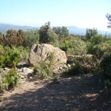
The dolmen stands at 592 m on the Coll de la Llosa, reached only by unmarked paths through Mediterranean forest. The nearest road, a narrow departmental road, lies several hundred metres to the east, and a forest track 200 m to the west. The dolmen of les Rieres is 1.5 km north, and a cup-marked stone possibly from a dolmen lies 150 m away on the same pass.
This monument sits at the boundary where three communes meet: Saint-Michel-de-Llotes, Bouleternère, and Casefabre. The location overlooks the valley of the Boulès river, revealing why ancient people chose this strategic and visible spot for their burial ground.
The community of curious travelers
AroundUs brings together thousands of curated places, local tips, and hidden gems, enriched daily by 93,811 contributors worldwide.