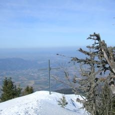
Signal de Nave, Limestone summit in Vercors massif, Isère, France.
Signal de Nave is a limestone summit in the Vercors range with rocky cliffs and open views. The peak overlooks the surrounding valleys and lower elevations of the Isère region.
The summit belongs to the same western ridge of the Vercors as the Bec de l'Orient (1,568 m), the rochers de la Clé (1,500 m), the rochers de Combes Noires (1,643 m) and la Buffe (1,623 m). Its 1,609 m top is built of Urgonian limestone, the rock typical of the massif, and it rises above the prairie de Fessole, some 200 m below on the western slope, and over the commune of La Rivière.
The summit's name, Signal, refers to its role as a lookout point on the western ridge of the Vercors. From the top, the view reaches the Voironnais, the Romans-sur-Isère area and the Terres froides, and the peak is visible from those lowlands in return. The prairie de Fessole lies 200 metres below on the western slope, above the commune of La Rivière.
Multiple marked trails lead to the summit from different starting points, with options for various skill levels. Sturdy footwear is recommended, and weather conditions at higher elevations can change quickly.
The summit sits on the same western ridge as the Bec de l'Orient (1,568 m), the rochers de Combes Noires (1,643 m) and la Buffe (1,623 m), and it drops about 200 metres straight to the prairie de Fessole on its western side. From the Voironnais, the Romans-sur-Isère area and the Terres froides, the peak is the landmark that marks this stretch of the ridge.
The community of curious travelers
AroundUs brings together thousands of curated places, local tips, and hidden gems, enriched daily by 94,460 contributors worldwide.