Punta di Caldane, Mountain summit in Haute-Corse, France.
Punta di Caldane is a 1,724-metre summit in the Caldane chain, a ridge of rounded, forest-covered eminences in the Monte San Petrone massif of central Corsica. A summit cross stands on the peak, which lies at the tripoint of the former pièves of Alesani, Bozio and Serra. The highest point of the chain, Cima di Calleruccio at 1,731 metres, is 800 metres to the north.
The summit stands at the tripoint of the former pièves of Alesani, Bozio and Serra, the districts that organised local administration in this part of Corsica. The ridge of the Caldane also marks the natural limit of the Castagniccia, the chestnut-growing region whose villages lie at the foot of its eastern slope.
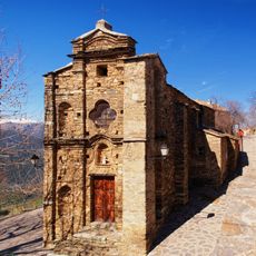
The ridge marks the natural boundary of Castagniccia, and from the summit cross on Punta di Caldane many villages at the foot of the eastern slope can be picked out below. Herders' stone bergeries such as those of Peri stand along the southern approach from Pianello, below the chapel of Saint-Vincent.
The most used route to the summit ridge climbs the south slope from Pianello, passing the Saint-Vincent chapel and the Peri sheepfolds. Another main approach is the col d'Orezza (1296 m), reached by a good path from Campodonico or Pie-d'Orezza. Trails are uneven and overgrown in places, and the massif's wet, changeable weather makes orientation difficult.
The summit cross stands on Punta di Caldane at 1,724 m, while the range's highest point, Cima di Calleruccio at 1,731 m, lies about 800 m to the north. The ridge forms the natural boundary of the Castagniccia, and many villages at the foot of its eastern slope can be picked out from the crest.
The community of curious travelers
AroundUs brings together thousands of curated places, local tips, and hidden gems, enriched daily by 93,674 contributors worldwide.