Enable Location

We need your location to show you interesting places around you

Discover nearby places

Find interesting locations and hidden gems around you

Precise directions

Get accurate directions and distances to places

Your location is never shared with other users. It's only used when you tap the location button.

Puech de Rascas

Log in to your account

Start exploring — it's free

Trusted by 61,994 travelers worldwide

Continue with Google
Continue with Apple
or

We will send you a code to connect

By continuing, you accept our Terms and Conditions and our Privacy Policy

Check your inbox

We've sent a pincode in your inbox. Please enter the code below.

Puech de Rascas

Puech de Rascas, Military summit in Lacaune Mountains, France

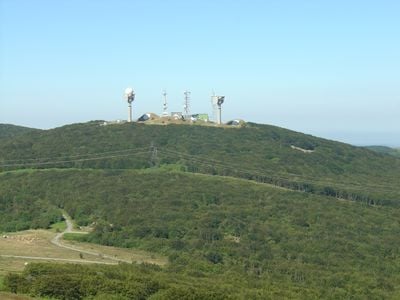
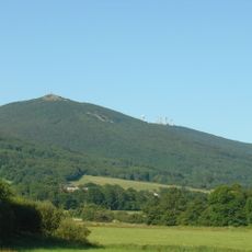
Puech de Rascas is a mountain summit in the Lacaune range that reaches 1270 meters and serves as the highest point in the Tarn department. The peak is fully occupied by radar and radio installations that dominate the upper plateau.

The summit came under military control and became equipped with radar and radio stations under the command of Air Base 125 Istres-Le Tubé. Since its military establishment, it has served as a strategic position for communications and surveillance operations.

The name 'Puech' comes from Occitan, the old language spoken in this part of France, and means mountain peak. This word choice reflects how the local landscape shaped the way people here talked about their land.

The summit is strictly off limits to hikers because of the military installations that cover the entire peak. The surrounding mountain trails offer walkers a chance to explore the landscape from different viewpoints, though the top remains inaccessible.

The mountain is formed primarily of schist, a rock type that defines the geology of the Lacaune range. This particular stone composition gives the peak its distinctive character and sets it apart from other summits in the area.

The community of curious travelers

AroundUs brings together thousands of curated places, local tips, and hidden gems, enriched daily by 60,000 contributors worldwide.

Start exploring
Location
Elevation above the sea
1,267 m
GPS coordinates
43.68146,2.72817
Latest update
December 14, 2025 14:23
« Puech de Rascas - Military summit in Lacaune Mountains, France » is provided by Around Us (aroundus.com). Images and texts are derived from Wikimedia project under a Creative Commons license. You are allowed to copy, distribute, and modify copies of this page, under the conditions set by the license, as long as this note is clearly visible.

Discover hidden gems everywhere you go!

From secret cafés to breathtaking viewpoints, skip the crowded tourist spots and find places that match your style. Our app makes it easy with voice search, smart filtering, route optimization, and insider tips from travelers worldwide. Download now for the complete mobile experience.

Around Us App Screenshot

A unique approach to discovering new places

Le Figaro

All the places worth exploring

France Info

A tailor-made excursion in just a few clicks

20 Minutes

Around Us
Travel Guide & Maps
Download

Send to your phone

QR Code
1

Open the camera app on your mobile.

2

Point at the QR code with your camera. A notification will appear.

3

Tap the notification to open the link.