Pic de l'Aspre, Mountain peak in Plantaurel massif, Ariège, France
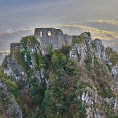
The Pic de l'Aspre rises to 1,011 m in the commune of Soula, Ariège, and is the highest point of the Plantaurel, a limestone chain of the Pyrenean foothills. Pale grey rock forms steep cliffs below an uneven crest with two higher sections and rounded knolls; dark green vegetation covers the slopes down to the fields.
The sources record no historical events for the Pic de l'Aspre; its documented past is that of the trails. The GR 107 and GR 367 share a path below the summit, and a shortcut variant climbs to the top. West of the peak, between these trails and the hamlet of Caraybat, stand the dolomitic needles of Charla, cut by erosion.
The peak's name, Aspre, means "rough" in Occitan, fitting a limestone crest of the Plantaurel. Walkers on the shared GR 107 and GR 367 path pass below the summit, and a shortcut variant climbs to the top. West of the peak, between the trails and the hamlet of Caraybat, stand the dolomitic needles of Charla, cut by erosion.
The site is accessible via the GR 107 and GR 367 long-distance hiking trails that pass below the summit with a path connecting to the peak. Visitors should wear proper hiking boots and bring adequate gear for mountain activity.
The Charla dolomitic needles lie west of the summit, between the GR trails and the hamlet of Caraybat. Erosion carved these rock spires from the limestone of the Plantaurel. Hikers on the GR 107 and GR 367 pass below them before the shortcut path climbs to the 1,011 m top.
The community of curious travelers
AroundUs brings together thousands of curated places, local tips, and hidden gems, enriched daily by 94,338 contributors worldwide.