Chest opened
+${chestReward.xp} XP
Explorer
NOUVEAU ×${chestReward.collectible.quantity}
tapez pour fermer
Chest locked

Open chests in the app

Around Us is built for your phone — chests unlock when you walk, explore and capture nearby places.

Enable Location

We need your location to show you interesting places around you

Discover nearby places

Find interesting locations and hidden gems around you

Precise directions

Get accurate directions and distances to places

Your location is never shared with other users. It's only used when you tap the location button.

Log in to your account

Start exploring — it's free

Trusted by 72,970 travelers worldwide

Continue with Google
Continue with Apple
or

We will send you a code to connect

By continuing, you accept our Terms and Conditions and our Privacy Policy

Check your inbox

We've sent a pincode in your inbox. Please enter the code below.

Tête des Baumiers
Discussion Reviews Photo
30+ Popularity

Tête des Baumiers, Mountain summit in Vercors region, France.

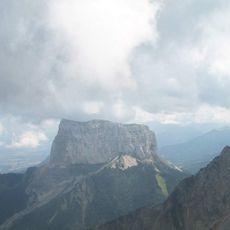
Tête des Baumiers is a mountain summit in the Vercors region that rises to 1811 meters and sits within the foothills of the French Alps. From the top, walkers see a panoramic spread of forested valleys, limestone cliffs, and the distinctive peak of Mont Aiguille in the distance.

The mountain has been a site of pastoral use for centuries, with old shepherd structures still visible along various trails. These remnants show how communities once relied on the higher slopes for seasonal grazing and mountain farming.

Local hiking traditions include an annual group ascent to Tête des Baumiers, connecting multiple generations of mountaineers from nearby communities.

The starting point is near Richardière hamlet, where marked trails lead through forested slopes toward the summit. The walk takes about five to six hours for most people, so start early and bring layers since weather changes quickly at altitude.

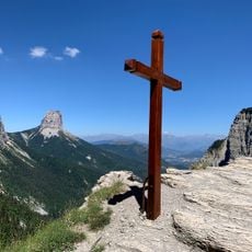
The north face descent of Tête des Baumiers presents an uncommon trail configuration that combines forest paths and limestone rock formations.

The community of curious travelers

AroundUs brings together thousands of curated places, local tips, and hidden gems, enriched daily by 60,000 contributors worldwide.

Start exploring
Elevation above the sea
1,811 m
GPS coordinates
44.80056,5.51722
Latest update
December 15, 2025 13:25
Reviews
Share your experience

No review yet

Discussions
Start a discussion...

No discussion yet

« Tête des Baumiers - Mountain summit in Vercors region, France » is provided by Around Us (aroundus.com). Images and texts are derived from Wikimedia project under a Creative Commons license. You are allowed to copy, distribute, and modify copies of this page, under the conditions set by the license, as long as this note is clearly visible.

Discover hidden gems everywhere you go!

From secret cafés to breathtaking viewpoints, skip the crowded tourist spots and find places that match your style. Our app makes it easy with voice search, smart filtering, route optimization, and insider tips from travelers worldwide. Download now for the complete mobile experience.

Around Us App Screenshot

A unique approach to discovering new places

Le Figaro

All the places worth exploring

France Info

A tailor-made excursion in just a few clicks

20 Minutes

Around Us
Travel Guide & Maps
Download

Send to your phone

QR Code
1

Open the camera app on your mobile.

2

Point at the QR code with your camera. A notification will appear.

3

Tap the notification to open the link.