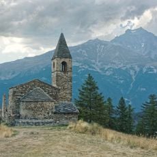
Mont Froid, Mountain summit in Savoie, France
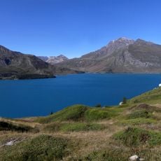
Mont Froid rises to 2,822 meters (9,259 feet) in the northern Cottian Alps with distinctive blackish schist formations and a gypsum base near the Italian border. The summit can be accessed via hiking trails and rewards climbers with panoramic views of surrounding mountain ranges and alpine lakes.
Between 1897 and 1906 French military forces built Fort du Mont-Froid to control passage through the alpine routes toward the Italian border. This fortification remains visible on the mountain and reflects France's historical focus on defending its southeastern frontier.
French mountain troops conduct regular winter training exercises at Mont Froid, maintaining a long tradition of alpine military preparation in the region.
Climbers can reach the summit from the Petit Mont Cenis refuge without technical climbing gear between June and mid-September if weather cooperates. Hikers should monitor conditions and adjust their equipment to the alpine terrain they will encounter.
A memorial cross marks the summit and honors the mountain's military past, while views stretch to the Massif de la Vanoise glaciers in the north and Lake Savine in the south. These distinctive landmarks at the top help visitors appreciate how deeply the mountain is tied to France's alpine story.
Location: Savoie
Elevation above the sea: 2,822 m
GPS coordinates: 45.23744,6.84288
Latest update: December 14, 2025 20:01
Mont Cenis Lake
7 km
Le Monolithe de Sardières
6 km
Forts de l'Esseillon
8.7 km
Forte Varisello
7.7 km
Ancien fort de Pattacreuse
5.2 km
Pointe Droset
6.6 km
Église Saint-Pierre d’Extravache
3.8 km
Dents d'Ambin
8.6 km
Pointe de Bellecombe
2.3 km
Jardin botanique de Mont Cenis
5.2 km
Signal du Petit Mont-Cenis
2.5 km
Chapelle Saint-Sébastien de Lanslevillard
7.8 km
Fort Marie-Christine
8.7 km
St Michael's Church of Lanslevillard
7.9 km
Chapelle Notre-Dame-de-la-Visitation de Termignon
5.1 km
Église Notre-Dame-de-l'Assomption d'Aussois
8 km
Église Notre-Dame de l'Assomption
5.9 km
Ancienne église
5.9 km
Église Notre-Dame-de-l'Assomption de Termignon
5 km
Église Saint-Laurent de Sardières
4.8 km
Chapelle Notre-Dame-de-la-Délivrance de Bramans
4 km
Chapelle Sainte-Barbe de Sardières
4.9 km
Chapelle Saint-André de Termignon
4.7 km
Gravures rupestres d'Aussois
7.1 km
Chapelle Notre-Dame-de-la-Salette
8.1 km
Chapelle Notre-Dame-de-l'Assomption dite la Pyramide de Mont-Cenis
8.5 km
Chapelle du fort du fort Victor-Emmanuel
8.7 km
Chapelle Saint-Roch de Termignon
5.1 kmVisited this place? Tap the stars to rate it and share your experience / photos with the community! Try now! You can cancel it anytime.
Discover hidden gems everywhere you go!
From secret cafés to breathtaking viewpoints, skip the crowded tourist spots and find places that match your style. Our app makes it easy with voice search, smart filtering, route optimization, and insider tips from travelers worldwide. Download now for the complete mobile experience.
A unique approach to discovering new places❞
— Le Figaro
All the places worth exploring❞
— France Info
A tailor-made excursion in just a few clicks❞
— 20 Minutes