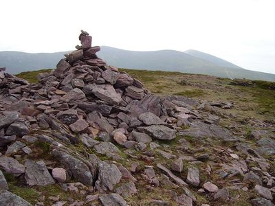
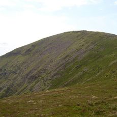
Sugarloaf Hill, Mountain peak in Knockmealdown Mountains, Ireland.
Sugarloaf Hill is a mountain summit in the Knockmealdown range, positioned between County Tipperary and County Waterford at 663 meters elevation. The peak is composed of medium-grained pink-purple sandstone that forms the distinctive geological character of this part of the mountain range.
The mountain formed over millions of years through geological processes that created the distinctive sandstone layers visible today. These ancient formations have remained largely unchanged since their initial creation, preserving the geological record of the region.
The local Irish name Cnoc na gCloch translates to hill of the stones, reflecting how the landscape has been named and remembered by people living nearby. This traditional name shows how geography shapes language and local identity in the region.
Multiple trails lead to the summit starting from parking areas at Bay Lough or The Vee, with hiking times varying from 45 to 90 minutes depending on your route choice. Sturdy footwear is essential, and visitors should prepare for changing weather conditions since elevation can bring rapid shifts in temperature and visibility.
From the summit, visitors can see three separate mountain ranges in one view: the Golden Vale, the Comeraghs, and the Galtee Mountains stretching across the horizon. This broad panorama makes the location special for those wanting to observe multiple ranges at once.
The community of curious travelers
AroundUs brings together thousands of curated places, local tips, and hidden gems, enriched daily by 60,000 contributors worldwide.