River Foyle

Log in to your account

AroundUs is a community-driven map of interesting places, built by curious explorers like you. It grows with every review, story, and photo you share.
Connect to save your favorite spots, contribute locations, and create personalized routes.
By continuing, you accept our Terms and Conditions and our Privacy Policy
Add to collection
Map
Suggest a change
Share

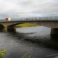
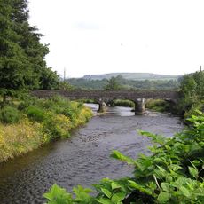
River Foyle, River system in Northern Ireland and Republic of Ireland.

The River Foyle is a river system that connects lands in both the Republic of Ireland and Northern Ireland, flowing from upland areas toward the Atlantic coast. It winds through different landscapes, creating wide valleys and estuaries along its path.

This river played a strategic role during World War II, when its estuary was used for military operations. That period left marks on the region's past and in local memory.

The riverbanks serve as gathering places where local people fish and celebrate seasonal events together. These traditions connect communities on both sides of the border.

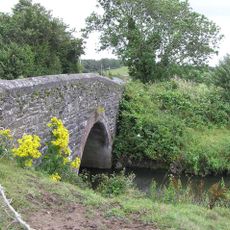
The river is accessible from several spots, especially near its mouth and along walking paths. Visitors should watch for tides and wear sturdy shoes when exploring the different areas.

Two special lamprey species live in the riverbed, using their specialized mouths to attach to larger fish. These rare residents are often hidden from view, yet their presence shows the river's ecological richness.

Location: County Donegal

Location: Derry City and Strabane

GPS coordinates: 54.82933,-7.48050

Latest update: December 7, 2025 19:23

Photos
Around this place
Beltany stone circle
Ireland

Beltany stone circle

8.3 km
Mongavlin Castle
Ireland

Mongavlin Castle

8.5 km
St Eunan's Cathedral
Ireland

St Eunan's Cathedral

9 km
Lifford Bridge
United Kingdom

Lifford Bridge

197 m
Raphoe Castle
Ireland

Raphoe Castle

8.9 km
Harry Avery's Castle
United Kingdom

Harry Avery's Castle

1.6 km
Stewart Castle
United Kingdom

Stewart Castle

14 km
Lifford Courthouse
Ireland

Lifford Courthouse

435 m
County House, Lifford
Ireland

County House, Lifford

466 m
Newtownstewart Town Hall
United Kingdom

Newtownstewart Town Hall

13.9 km
Steinkiste von Newtownstewart
United Kingdom

Steinkiste von Newtownstewart

14 km
Church Of The Good Shepherd Melmount Road Sion Mills Co. Tyrone Bt82 9et
United Kingdom

Church Of The Good Shepherd Melmount Road Sion Mills Co. Tyrone Bt82 9et

5.1 km
Killygordon Bridge
Ireland

Killygordon Bridge

13.6 km
Second Raphoe Presbyterian Church
Ireland

Second Raphoe Presbyterian Church

9 km
Christ Church, Bell Road, Urney, Strabane, Co Tyrone Bt82 9rs
United Kingdom

Christ Church, Bell Road, Urney, Strabane, Co Tyrone Bt82 9rs

4.4 km
St Lugadius Church of Ireland
Ireland

St Lugadius Church of Ireland

545 m
Commodore Cinema
United Kingdom

Commodore Cinema

1.1 km
St Theresa's Rc Church 145 Melmount Road Sion Mills Strabane Co. Tyrone Bt82 9ex
United Kingdom

St Theresa's Rc Church 145 Melmount Road Sion Mills Strabane Co. Tyrone Bt82 9ex

4.7 km
Swilly Bridge
Ireland

Swilly Bridge

5.8 km
Clady Bridge
Ireland

Clady Bridge

5.8 km
Christ Church (c Of I) Bowling Green Strabane County Tyrone Bt82 8bw
United Kingdom

Christ Church (c Of I) Bowling Green Strabane County Tyrone Bt82 8bw

1.3 km
Herdmans' Mill Mill Avenue Sion Mills Liggartown Strabane Co Tyrone Bt82 9he
United Kingdom

Herdmans' Mill Mill Avenue Sion Mills Liggartown Strabane Co Tyrone Bt82 9he

4.8 km
Glencush Bridge Ballyheather Road Strabane Co.tyrone Bt82
United Kingdom

Glencush Bridge Ballyheather Road Strabane Co.tyrone Bt82

10.3 km
Gray's Stationery Shop (and Printing Presses) 49 Main Street Strabane Co. Tyrone Bt82 8au
United Kingdom

Gray's Stationery Shop (and Printing Presses) 49 Main Street Strabane Co. Tyrone Bt82 8au

1.2 km
Wilson House 28 Spout Road Dergalt Strabane Co. Tyrone Bt82 8nb
United Kingdom

Wilson House 28 Spout Road Dergalt Strabane Co. Tyrone Bt82 8nb

4 km
Newtownstewart Library
United Kingdom

Newtownstewart Library

14 km
Church of Ireland Bishop’s Palace, Raphoe
Ireland

Church of Ireland Bishop’s Palace, Raphoe

8.9 km
Gate Lodge Zion House Melmount Road Sion Mills Co.tyrone
United Kingdom

Gate Lodge Zion House Melmount Road Sion Mills Co.tyrone

4.7 km
Show the full map
Reviews

Visited this place? Tap the stars to rate it and share your experience / photos with the community! Try now! You can cancel it anytime.

« River Foyle - River system in Northern Ireland and Republic of Ireland » is provided by Around Us (aroundus.com). Images and texts are derived from Wikimedia project under a Creative Commons license. You are allowed to copy, distribute, and modify copies of this page, under the conditions set by the license, as long as this note is clearly visible.

Discover hidden gems everywhere you go!

From secret cafés to breathtaking viewpoints, skip the crowded tourist spots and find places that match your style. Our app makes it easy with voice search, smart filtering, route optimization, and insider tips from travelers worldwide. Download now for the complete mobile experience.

Around Us App Screenshot

A unique approach to discovering new places

Le Figaro

All the places worth exploring

France Info

A tailor-made excursion in just a few clicks

20 Minutes