Enable Location

We need your location to show you interesting places around you

Discover nearby places

Find interesting locations and hidden gems around you

Precise directions

Get accurate directions and distances to places

Your location is never shared with other users. It's only used when you tap the location button.

Log in to your account

Start exploring — it's free

Trusted by 61,903 travelers worldwide

Continue with Google
Continue with Apple
or

We will send you a code to connect

By continuing, you accept our Terms and Conditions and our Privacy Policy

Check your inbox

We've sent a pincode in your inbox. Please enter the code below.

Yadgir district, Administrative district in Karnataka, India

Yadgir District is an administrative region in Karnataka with rich black soil spread across roughly 5,200 square kilometers. Towns and villages are connected by roads and surrounded by agricultural land that defines the local landscape.

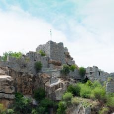
The region served as the capital of the Yadava dynasty in the 14th and 15th centuries, making it politically important at that time. Before this period, the Satavahanas and Chalukyas had ruled these lands across different eras.

Kannada is the language you hear most often in daily life, and different religious communities coexist throughout the region. Their traditions shape local customs and how people celebrate important occasions together.

The district has schools and hospitals serving both residents and visitors, with road connections linking the various towns and villages. The cooler season offers the most comfortable weather for traveling through the region.

The region stands out for growing red gram and sorghum in its black soil, playing a key role in grain production across the state. These crops are central to the local economy and feed markets far beyond the district itself.

The community of curious travelers

AroundUs brings together thousands of curated places, local tips, and hidden gems, enriched daily by 60,000 contributors worldwide.

Start exploring
Capital city
Yadgir
Shares border with
Vijaypura District
GPS coordinates
16.76667,77.13333
Latest update
December 20, 2025 14:29
« Yadgir district - Administrative district in Karnataka, India » is provided by Around Us (aroundus.com). Images and texts are derived from Wikimedia project under a Creative Commons license. You are allowed to copy, distribute, and modify copies of this page, under the conditions set by the license, as long as this note is clearly visible.

Discover hidden gems everywhere you go!

From secret cafés to breathtaking viewpoints, skip the crowded tourist spots and find places that match your style. Our app makes it easy with voice search, smart filtering, route optimization, and insider tips from travelers worldwide. Download now for the complete mobile experience.

Around Us App Screenshot

A unique approach to discovering new places

Le Figaro

All the places worth exploring

France Info

A tailor-made excursion in just a few clicks

20 Minutes

Around Us
Travel Guide & Maps
Download

Send to your phone

QR Code
1

Open the camera app on your mobile.

2

Point at the QR code with your camera. A notification will appear.

3

Tap the notification to open the link.