Enable Location

We need your location to show you interesting places around you

Discover nearby places

Find interesting locations and hidden gems around you

Precise directions

Get accurate directions and distances to places

Your location is never shared with other users. It's only used when you tap the location button.

Log in to your account

Start exploring — it's free

Trusted by 62,801 travelers worldwide

Continue with Google
Continue with Apple
or

We will send you a code to connect

By continuing, you accept our Terms and Conditions and our Privacy Policy

Check your inbox

We've sent a pincode in your inbox. Please enter the code below.

Hingoli district

Hingoli district, Administrative district in Maharashtra, India

Hingoli district is an administrative region in northern Marathwada that borders four neighboring districts in Maharashtra state. The area is divided into two subdivisions and five talukas, with Hingoli city serving as the administrative seat and main transportation hub.

The British East India Company established the district in the mid-1800s as an administrative center for the South Berar region. After 1857, control shifted to the Nizam, which determined the territory's political direction for decades to come.

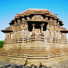
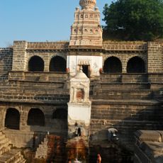
The Aundha Nagnath Temple draws pilgrims who come to worship at one of Hinduism's most sacred shrine locations in the region. Visitors experience the spiritual energy and devotional practices that have shaped the local religious life for centuries.

The best visiting period is during cooler months when weather conditions are more comfortable. A vehicle is helpful for getting around, as settlements are spread out and public transportation options are limited.

The region was recognized as a priority district under a national development program aimed at advancing its economic growth. This program focuses on improving infrastructure and local services in areas designated for accelerated development.

The community of curious travelers

AroundUs brings together thousands of curated places, local tips, and hidden gems, enriched daily by 60,000 contributors worldwide.

Start exploring
Capital city
Hingoli
Shares border with
Parbhani district, Washim district
GPS coordinates
19.71670,77.15000
Latest update
December 20, 2025 12:30
« Hingoli district - Administrative district in Maharashtra, India » is provided by Around Us (aroundus.com). Images and texts are derived from Wikimedia project under a Creative Commons license. You are allowed to copy, distribute, and modify copies of this page, under the conditions set by the license, as long as this note is clearly visible.

Discover hidden gems everywhere you go!

From secret cafés to breathtaking viewpoints, skip the crowded tourist spots and find places that match your style. Our app makes it easy with voice search, smart filtering, route optimization, and insider tips from travelers worldwide. Download now for the complete mobile experience.

Around Us App Screenshot

A unique approach to discovering new places

Le Figaro

All the places worth exploring

France Info

A tailor-made excursion in just a few clicks

20 Minutes

Around Us
Travel Guide & Maps
Download

Send to your phone

QR Code
1

Open the camera app on your mobile.

2

Point at the QR code with your camera. A notification will appear.

3

Tap the notification to open the link.