Panicale, Italian comune
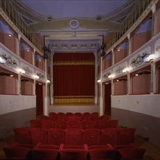
Panicale is a small commune in the province of Perugia in Umbria, located on a hilltop surrounded by ancient stone walls that define its perimeter. The town features narrow paved streets, traditional buildings in warm earth tones, several churches with artwork spanning centuries, a Renaissance-era theater still used for performances, and a museum dedicated to fine embroidery on tulle.
Panicale was founded as a medieval settlement and developed over centuries thanks to its strategic hilltop position, which provided defensive advantages against invaders. The town absorbed influences from Etruscans, Romans, and medieval powers, each leaving their mark through architectural styles and artistic traditions.
Panicale expresses its identity through traditional craftsmanship, especially fine embroidery on tulle that local artisans still practice today. The town's religious art, housed in its churches, shows how faith and creativity have shaped daily life and celebrations for centuries.
Spring and early autumn offer the most pleasant weather for exploring the town comfortably on foot through its narrow streets. Limited parking within town walls means arriving early or leaving your vehicle in designated areas outside, allowing you to navigate the medieval lanes without restrictions.
The town overlooks Lake Trasimeno, site of one of antiquity's largest battles between Romans and Carthaginians, and many visitors come specifically to explore the battle sites and understand this pivotal ancient conflict. The lake's shores and surrounding settlements preserve memories of this dramatic historical event.
The community of curious travelers
AroundUs brings together thousands of curated places, local tips, and hidden gems, enriched daily by 60,000 contributors worldwide.