Lake Vico, Volcanic caldera lake in Lazio, Italy
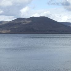
Lake Vico is a volcanic crater lake situated in the Cimini Mountains at about 507 meters elevation, covering roughly 13 square kilometers of water. The lake reaches depths of about 48 meters and is surrounded by forested slopes on all sides.
Lake Vico fills the caldera of Vico Volcano, built by eruptions between 305,000 and 258,000 years ago. Pyroclastic flows and ash caused the cone to collapse, forming the caldera by about 138,000 years ago. In Roman times an artificial conduit was cut into the tuff to feed the Vicano river; the Farnese family reactivated it in the 16th century, lowering the water level and turning the northern Pantanacce into farmland.
The name Vico may come from Vicus Matrini, a Roman settlement on the Via Cassia, or from Vicus Elbii, a small Roman village on the lake's southern edge that had vanished by the early Middle Ages. The Via Ciminia, an alternative to the Via Cassia, crossed this area and brought wealth to the Prefetti di Vico and later the Farnese.
The lake lies in the caldera of Vico Volcano, ringed by the SP 39 road; a hang-glider and paraglider launch ramp on the north-western slope gives a wide view over the water and the Venere and Fogliano mountains. Bathing establishments with restaurants or picnic areas operate around the shore, and marked trekking routes cross the reserve. The outlet tunnel keeps the water level regulated, so the northern Pantanacce flats can be muddy.
The lake's outlet tunnel, cut through tuff in Roman times and reactivated by the Farnese in the 16th century, runs about 400 metres beneath the ridge, its vault held by brick courses. Lowering the water level turned the northern caldera floor, the Pantanacce, into farmland and left Mount Venere as a peninsula-turned-hill, giving the basin its horseshoe shape.
The community of curious travelers
AroundUs brings together thousands of curated places, local tips, and hidden gems, enriched daily by 95,031 contributors worldwide.