Enable Location

We need your location to show you interesting places around you

Discover nearby places

Find interesting locations and hidden gems around you

Precise directions

Get accurate directions and distances to places

Your location is never shared with other users. It's only used when you tap the location button.

Via ferrata del Passo Santner

Log in to your account

Join the adventure

Create your free account and start exploring (like 60k+ others)

We will send you a code to connect

or
Continue with Google
Continue with Apple
By continuing, you accept our Terms and Conditions and our Privacy Policy

Check your inbox

We've sent a pincode in your inbox. Please enter the code below.

Via ferrata del Passo Santner

Via ferrata del Passo Santner, Mountain climbing route in Welschnofen, Italy.

Description

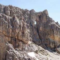
The Via Ferrata del Passo Santner runs through steep rock faces at elevations between 2,337 ft (711 m) and 2,741 ft (836 m) in the western section of Mount Catinaccio. The route is equipped with steel cables, ladders, and anchors that guide climbers over exposed sections.

History

This climbing path originated during the early expansion of Dolomites exploration around 1900, when metal equipment revolutionized mountaineering. The Santner Pass became part of a network of routes that opened access to previously unreachable summits.

Culture

The route represents the Italian Alpine tradition of making mountain peaks accessible through protected climbing paths equipped with steel cables and metal rungs. Visitors experience today how such paths shape mountaineering and bring together climbers of different skill levels.

Practical

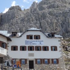
Visitors need a helmet, via ferrata equipment, climbing boots, and plenty of water to prepare for the demanding climb. Access is via a cable car from Malga Frommer station, and good weather plus rock climbing experience are essential.

Did you know?

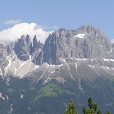
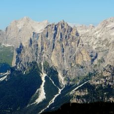
The route cuts through vertical walls and leads climbers onto exposed ridges where the nearby Vajolet Towers come into direct view. These distinctive red rock spires create a memorable backdrop throughout the ascent to Santner Pass.

Location
Elevation above the sea
2,337 m
GPS coordinates
46.44269,11.61397
Latest update
December 14, 2025 18:01

AroundUs brings together thousands of curated places, local tips, and hidden gems, enriched daily by 60,000 contributors worldwide. Discover all places nearby (Welschnofen).

« Via ferrata del Passo Santner - Mountain climbing route in Welschnofen, Italy » is provided by Around Us (aroundus.com). Images and texts are derived from Wikimedia project under a Creative Commons license. You are allowed to copy, distribute, and modify copies of this page, under the conditions set by the license, as long as this note is clearly visible.

Discover hidden gems everywhere you go!

From secret cafés to breathtaking viewpoints, skip the crowded tourist spots and find places that match your style. Our app makes it easy with voice search, smart filtering, route optimization, and insider tips from travelers worldwide. Download now for the complete mobile experience.

Around Us App Screenshot

A unique approach to discovering new places

Le Figaro

All the places worth exploring

France Info

A tailor-made excursion in just a few clicks

20 Minutes

Around Us
Travel Guide & Maps
Download

Send to your phone

QR Code
1

Open the camera app on your mobile.

2

Point at the QR code with your camera. A notification will appear.

3

Tap the notification to open the link.