Geography of Sri Lanka, Tropical island country in Indian Ocean, Sri Lanka.
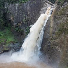
Sri Lanka is an island in the Indian Ocean covering roughly 65600 square kilometers with a coastline of around 1340 kilometers. The landscape shifts between a central highland with peaks rising above 2000 meters (about 6500 feet), flat plains in the north, and dense vegetation along the southwest and west coasts.
The land bridge between Sri Lanka and India was severed after a severe storm in 1480 widened the Palk Strait. Since then, the island has been completely separated from the mainland, though the distance to the Indian coast remains only about 30 kilometers (roughly 19 miles).
The large reservoirs in the north and east serve as engineering works that have also become important habitats for migratory birds. Fishermen work there using traditional methods and live closely tied to the seasonal rhythm.
The northeast monsoon brings rain to the east and north coasts between December and March, while the southwest monsoon affects the west and south coasts from June to October. Visitors heading to the central highlands should bring a jacket even during warmer months, as temperatures there drop considerably.
More than 90 percent of the surface rests on Precambrian rock formations, with some sections around 2 billion years old. These ancient formations appear in many places and shape the landscape with their dark rock masses and reddish soils.
The community of curious travelers
AroundUs brings together thousands of curated places, local tips, and hidden gems, enriched daily by 60,000 contributors worldwide.