Sluis- en Stuwcomplex Amerongen

Log in to your account

AroundUs is a community-driven map of interesting places, built by curious explorers like you. It grows with every review, story, and photo you share.
Connect to save your favorite spots, contribute locations, and create personalized routes.
Continue with Google
Continue with Apple
Continue with X
Continue with Facebook
Continue with email
By continuing, you accept our Terms and Conditions and our Privacy Policy
Create an account

Sluis- en Stuwcomplex Amerongen

Add to collection
Map
Suggest a change
Share

Sluis- en Stuwcomplex Amerongen, Hydroelectric power station and lock complex in Utrechtse Heuvelrug, Netherlands

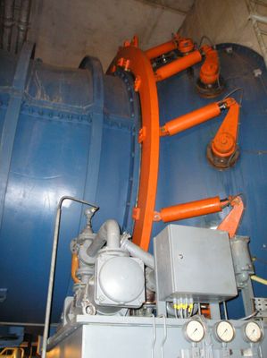
The Sluis- en Stuwcomplex Amerongen is a combination of lock and weir on the Nederrijn River, designed to control water levels while allowing vessels to pass through. The lock chamber stretches about 260 meters (850 feet) long and can be divided into sections to accommodate different ship sizes.

Construction started in 1958 and finished in 1965 as part of a broader water management strategy for northern Netherlands. The project emerged when the country was modernizing its infrastructure to handle rivers more safely and efficiently.

The complex reflects Dutch practices of living with rivers and harnessing their power, traditions that have shaped the region for centuries. You can observe how the area balances human needs with respect for the waterway's role in the landscape.

The site is accessible and offers viewpoints to observe the lock and weir operations from different angles. Visiting during operating hours gives you the best chance to see the machinery and water levels in action.

The facility powers itself through a 10-megawatt hydroelectric generator built into its operations, making it a working example of navigational and renewable energy infrastructure in tandem. Few visitors realize the electricity produced here comes from the river's own flow while boats pass through.

Location: Utrechtse Heuvelrug

GPS coordinates: 51.97472,5.40917

Latest update: December 11, 2025 11:08

Photos
Around this place
Natewisch, Amerongen
Netherlands

Natewisch, Amerongen

1.3 km
Zuilenburg
Netherlands

Zuilenburg

2.5 km
Bergestein
Netherlands

Bergestein

892 m
Dompselaer
Netherlands

Dompselaer

2.6 km
De Hoop
Netherlands

De Hoop

1.6 km
Sint-Maartenskerk, Maurik
Netherlands

Sint-Maartenskerk, Maurik

1.7 km
Nederlands Hervormde Kerk, Eck en wiel
Netherlands

Nederlands Hervormde Kerk, Eck en wiel

3.3 km
Veerhuis
Netherlands

Veerhuis

3.4 km
Garststraat 15, Maurik
Netherlands

Garststraat 15, Maurik

1.4 km
Nederlands Hervormde Kerk, Overlangbroek
Netherlands

Nederlands Hervormde Kerk, Overlangbroek

2.5 km
De Ark, Amerongen
Netherlands

De Ark, Amerongen

2.7 km
Vredestein
Netherlands

Vredestein

3.2 km
Langbroekerdijk B 38, Overlangbroek
Netherlands

Langbroekerdijk B 38, Overlangbroek

2.3 km
Langhuisboerderij
Netherlands

Langhuisboerderij

3.1 km
Town hall of Buren
Netherlands

Town hall of Buren

2.3 km
Langbroekerdijk B 11, Langbroek
Netherlands

Langbroekerdijk B 11, Langbroek

2.8 km
Langbroekerdijk B 24, Langbroek
Netherlands

Langbroekerdijk B 24, Langbroek

2.8 km
Lekdijk 5, Amerongen
Netherlands

Lekdijk 5, Amerongen

1.9 km
Boerderij op T-vormige plattegrond, waarvan het woongedeelte een zadeldak tussen puntgevels bezit en rechts een opkamer. Vensters met luiken en zes- en vierruitsschuiframen
Netherlands

Boerderij op T-vormige plattegrond, waarvan het woongedeelte een zadeldak tussen puntgevels bezit en rechts een opkamer. Vensters met luiken en zes- en vierruitsschuiframen

3.4 km
Toren der Herv.Kerk. Sober, vroeg-gotisch bouwwerk, met korte, ingesnoerde spits
Netherlands

Toren der Herv.Kerk. Sober, vroeg-gotisch bouwwerk, met korte, ingesnoerde spits

3.3 km
Garststraat 58, Maurik
Netherlands

Garststraat 58, Maurik

1.4 km
Terrein waarin overblijfselen van het versterkte huis Natewisch
Netherlands

Terrein waarin overblijfselen van het versterkte huis Natewisch

1.3 km
Gepleisterde boerderij op T-vormige plattegrond
Netherlands

Gepleisterde boerderij op T-vormige plattegrond

1.9 km
Huis ten oosten van de kerk op de hoek van het kerkplein en de kerkweg
Netherlands

Huis ten oosten van de kerk op de hoek van het kerkplein en de kerkweg

1.7 km
Toren der hervormde kerk
Netherlands

Toren der hervormde kerk

1.7 km
Langbroekerdijk B 26, Langbroek
Netherlands

Langbroekerdijk B 26, Langbroek

2.7 km
Kasteel Zuilenburg : Terrein waarin de overblijfselen van het versterkte huis Zuylenburg
Netherlands

Kasteel Zuilenburg : Terrein waarin de overblijfselen van het versterkte huis Zuylenburg

2.5 km
Boerderij, wit gepleisterd bakstenen gebouwtje onder een afgewolfd rieten zadeldak
Netherlands

Boerderij, wit gepleisterd bakstenen gebouwtje onder een afgewolfd rieten zadeldak

3.5 km
Show the full map
Reviews

Visited this place? Tap the stars to rate it and share your experience / photos with the community! Try now! You can cancel it anytime.

« Sluis- en Stuwcomplex Amerongen - Hydroelectric power station and lock complex in Utrechtse Heuvelrug, Netherlands » is provided by Around Us (aroundus.com). Images and texts are derived from Wikimedia project under a Creative Commons license. You are allowed to copy, distribute, and modify copies of this page, under the conditions set by the license, as long as this note is clearly visible.

Discover hidden gems everywhere you go!

From secret cafés to breathtaking viewpoints, skip the crowded tourist spots and find places that match your style. Our app makes it easy with voice search, smart filtering, route optimization, and insider tips from travelers worldwide. Download now for the complete mobile experience.

Around Us App Screenshot

A unique approach to discovering new places

Le Figaro

All the places worth exploring

France Info

A tailor-made excursion in just a few clicks

20 Minutes