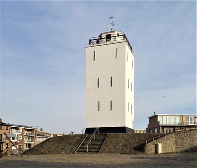
Vuurbaak Katwijk, Brick lighthouse in Katwijk aan Zee, Netherlands.
The Vuurbaak is a brick tower standing about 12 meters tall with a square design, located near the North Sea coast in Katwijk. The structure features a flat roof and solid masonry walls built to withstand the harsh coastal environment over centuries.
Built in 1605, this was one of the country's earliest lighthouses, originally lit by open flames in an iron basket on the roof. Over time it transitioned to coal and oil lamps as maritime traffic grew and technology improved.
This structure served as a vital guide for sailors navigating the North Sea, and it remains a symbol of the area's deep connection to maritime trade. Walking around the tower today, you can sense how central it was to the community's relationship with the sea.
The structure sits behind the coastal promenade at Vuurbaakplein with parking nearby and pedestrian access from the boulevard. Comfortable shoes are useful since you will be walking on uneven coastal terrain and around the base of the tower.
During World War I, the Royal Netherlands Navy used it as a lookout post with sailors maintaining constant watch over coastal waters. This military role reveals how central the structure was to defending the region's shores.
The community of curious travelers
AroundUs brings together thousands of curated places, local tips, and hidden gems, enriched daily by 60,000 contributors worldwide.